In October of 2019, the Mazama DEI (Diversity, Equity, and Inclusion) Working Group began visioning a statement that called upon our values as an organization towards work that is inclusive, equitable, and anti-racist. After review, the Executive Council approved the statement this October. This statement is at once a recognition of our current cultural climate at the Mazamas, a hopeful view of the future, and a commitment to do better.
The Equity Statement was a collaborative effort of the Mazama DEI Working Group, past Executive Director Mitsu Iwasaki, the current Mazama staff, and the Executive Council. This document is only our first version, and we look forward to continuing the discussion on how to be a more inclusive and just organization, particularly as we get feedback and engage in dialogue with our community who is most impacted by marginalization and injustice.
Mazama Equity Statement
By the Mazama DEI Working Group Adopted by the Mazama Executive Council 10/22/2020
The mission statement of the Mazamas is intrinsically tied to and depends on our organization prioritizing equity, inclusion, and diversity. We can’t inspire everyone to love and protect the mountains without acknowledging the exclusive history of the outdoor industry, and practicing an equitable approach moving forward. This history has created structural and cultural barriers, including indigenous erasure from the places we recreate in and care about so deeply, and stunted the potential for a wide diversity of people to love and protect the mountains.
While we have members and participants of many races, ages, and genders, the Mazamas currently is a largely white, affluent, and able-bodied organization, both in leadership and participation. Many of our structural and cultural practices further white supremacy by marginalizing, excluding, and oppressing the diversity of people who might otherwise participate in our programming. This is a loss to our organization morally and functionally. We believe diversity is important to the Mazamas because it broadens our knowledge, increases our creative ability to innovate, and creates a stronger and safer community for everyone. Diversity is about more than representation, it is fundamentally about inclusion. We can build diversity by practicing inclusion that actively prioritizes and elevates those who have been historically excluded from the Mazamas and the greater outdoor community.
We are very much in the beginning phases of our journey towards becoming an organization that can inspire everyone to love and protect the mountains. Our goals are to increase the safety and inclusion of all aspects of the Mazama experience by ensuring equitable resource dedication to all groups, intentional programming, and increased representation of traditionally marginalized people in our leadership. The Mazamas will actively recruit members of underrepresented groups to leadership positions within the organization in order to begin the process of creating a truly inclusive direction and vision. We understand that we need to address certain cultural norms, and actively work toward cultivating a culture of physical and psychological safety, where people trust they can participate as their whole selves.
We know that we still have, and will always have much work to do. Thank you for coming on this journey with us.
Article by David Hill, from the December 2020 Mazama
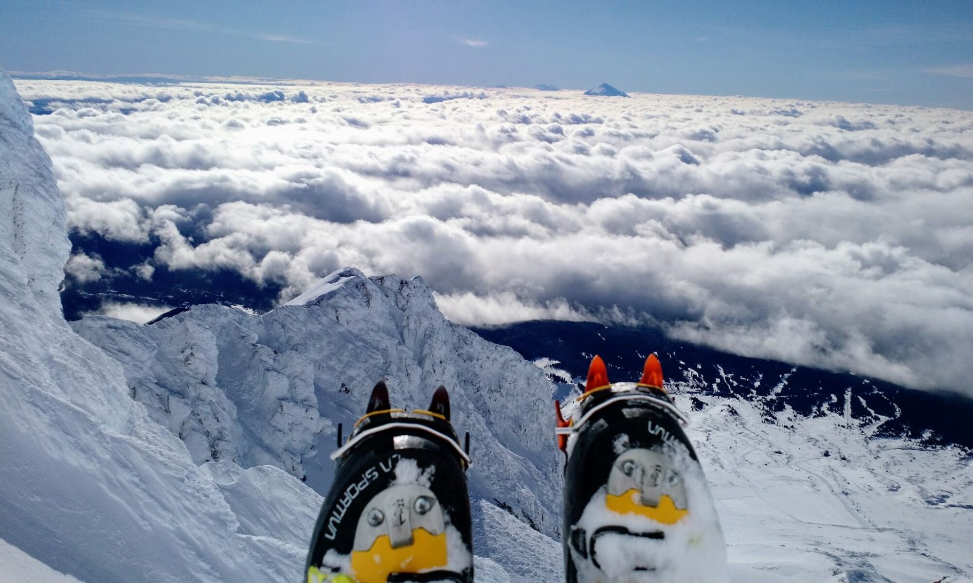
Sampling snow density with a federal sampler near Thompson Pass, Alaska. Photo: Ryan Crumley.
You don’t need to be a backcountry skier/rider or an alpinist to benefit from reliable information on the snowpack. Now, you probably are if you are reading this, so think about it for a minute…what do you typically want to know and where and when do you want to know it? You might be looking for an avalanche forecast right NOW, which requires site-specific information on the vertical structure and stability of the snowpack. You might be looking for less-detailed information on coverage in the near future– how long of a hike will you have from trailhead to snowline next weekend? Will the bergschrund at the base of the couloir you want to ski still be filled in two weeks from now? Will I have to wax for water again? And, could someone please tell me if the Pearly Gates will be in shape next month?
Well, even if the front country is more your style or (gasp!) you don’t even ski/ride/climb, you still benefit from information about the snow. Snowpack plays a huge role in regional water resources in the Pacific Northwest. Oregon and Washington each receive about 150 cubic kilometers of precipitation each year. In beer units, that’s 300 trillion pints of hoppy IPA, and a fair bit of that falls as snow. Water planners need regional-scale information on snow depth, density, and distribution in order to make accurate estimates of seasonal water yields months out into the future.
Meeting the information needs of these different user groups is a challenge because of these different spatial and temporal requirements. Fortunately, there are a lot of sources of snow data that can help, although they vary in terms of accuracy, coverage, and resolution. In-situ, or on the ground measurements have historically been the most common. These measurements include those made by personnel on the move in the field and also those at fixed, automated stations. An example of the former could be an avalanche forecaster, heli-ski guide, or ski patroller who records a measurement (pit profile, snow depth, snow density, etc.) in a database such as SnowPilot.
Sentinel satellite imagery of the Mt. Cook region, New Zealand
Fixed, automated snow telemetry (or SNOTEL) stations measure snow depth with an ultrasonic sensor and snow-water-equivalent (SWE) with a snow pillow, which is a fluid-filled bladder that measures pressure and therefore the weight of the overlying snowpack. In the western United States, we benefit from an incredible network of these stations, operated by the Natural Resources Conservation Service (NRCS). We have over 800 of these sites that are currently active, and many have periods of record of over 40 years. This is a gold mine of snow data that allows us to understand the current state of the snowpack and also how it has changed over the past several decades.
As if that was not good enough news, there are numerous remote sensing assets that are available to us. NASA has several missions that use airborne Light Detection and Ranging (LIDAR) to map snow depths in exquisite detail. At higher elevations still, there are many satellite missions (NASA, European Space Agency, etc.) that provide precise, high resolution images of snow cover and other snow-related information. The spatial coverage and the frequency of measurement vary among the different missions, and the measurements can be complicated by cloud cover and other environmental conditions.
Since no measurement campaign can measure everywhere, every time, computer modeling can be used to provide estimates on snowpack conditions at other places and times. At the national level, the National Operational Hydrologic Remote Sensing Center produces the Snow Data Assimilation System (SNODAS) data product, which has a 1 km spatial scale and a daily time step. SNODAS grids from 2003 up to today (it is an operational model) can be viewed at a number of websites including www.climateengine.org. The 1 km scale of SNODAS is fine for many applications such as water planning, but is too coarse to resolve local snow redistribution properties such as drifting and avalanching.
Sampling snow density with a federal sampler near Thompson Pass, Alaska. Photo: Ryan Crumley. Right: A sloppy day in coastal Alaska. Photo: Dave Hill
All of the data sources and modeling programs described above help snow scientists, snow safety professionals, and recreationists better understand the current state of the snowpack and also long-term (decadal scale) trends in snowpack characteristics. Opportunity still knocks, however. High-elevation regions of complex terrain are where most of the snow is found. However, that is not where the SNOTEL stations are. Due to the need for vehicular access for installation and maintenance, most SNOTEL sites are in areas of moderate elevation and gentle terrain.
The Community Snow Observations (CSO; communitysnowobs.org; @communitysnowobs) project began in 2017 to test the idea that backcountry users could help to fill the data gaps that exist in high-elevation mountain areas. In concept, it’s a perfect match. Backcountry skiers, riders, and climbers cover long distances, thrive in high elevations and in complex terrain, and go far away from roads! The CSO vision was that data crowd-sourced by the backcountry community would then be assimilated into high-resolution snowpack models, and these model products could be returned to the public to be obsessed over while planning shenanigans for the coming weekend. In addition, the data would be used in collaborations with other NASA programs that focus on snow processes. So, if you’ve ever dreamed of being a rocket scientist and working with NASA, here’s your chance!
The idea of creating a large network of community scientists is not a new one. In the context of weather and snow observations, the Community Collaborative Rain, Hail and Snow Network (CoCoRaHS) has observers distributed throughout the United States who measure rainfall, snowfall, and hail. However, the CoCoRaHS project is largely a ‘backyard observer’ type program and does not sample high alpine environments. And, community science does have some challenges. The measurements are opportunistic and depend upon decisions made by the participants themselves. CSO can offer some suggestions and guidance, but ultimately must rely on the decisions made by its participants about where and when data come from. Another challenge has to do with data quality control. Tutorials are provided but, in the end, CSO recognizes that measurements are coming from a diverse body of contributors with differing levels of experience with data collection.
Map of modeling domains and sample image of snowpack in western Wyoming. Image: Christina Aragon
Participating in CSO is quick and easy. Depth measurements are made with an avalanche probe or other measuring device. Protocols on making measurements and selecting representative sites are provided on the CSO website. Your smartphone is the second piece of gear you need. Even if you’re out of cell range, the GPS on your phone knows where you are and what time it is, critical pieces of information for the project. Third, you need to have the Mountain Hub app on your phone. Mountain Hub was founded in 2015 with a vision of a crowd-sourced information network for the outdoors. Mountain Hub was acquired by Mammut in 2017 and then just this summer, the CSO project acquired it. Easy-to-follow tutorials on using the app are also found at our website. With just a bit of practice, you can stop, assemble your probe, log a measurement and be on your way in a few minutes. So, stopping to shed a layer? Pull out your probe and send in the data. Ripping skins at the start of a descent? The snow needs a few more minutes to corn up…pull out your probe, check the depth, and tell us all about it. Cooling your heels waiting for your out-of-shape partner to catch up? Might as well do some snow science while you wait…and wait.
Participation in CSO has grown steadily since the project started. We have had about 15,000 submissions from about 3000 unique users around the globe. Measurements to date have been dominated by North America, but we are starting to make inroads in other areas around the globe.
Map of CSO submissions.
So, what’s in it for us? Well, CSO gets unique, high-elevation data that we get to study and share with NASA, and, as noted above, NASA gets to use these data points to validate many of their other snow measurements. But, community science should not be a one-way street. Successful community science projects are collaborative exchanges and CSO is invested in listening to our participants about ways to improve our project and also in delivering to our participants useful, timely information about snow in their region. The CSO project started up in Alaska and our model simulations there have demonstrated that data contributions from community scientists dramatically reduce errors in our snowpack models. Since then, as our project has grown, we have rolled out modeling efforts in many other areas in the western United States. The goal we are working toward is real-time, high-resolution snowpack information in all high elevation areas.
We named the project Community Snow Observations for a reason…community. Backcountry users who see the value in community science and who see the value in trading a bit of their time for the best available information on snow and water resources are the true core of CSO. There is no crowd-sourcing without the crowd and we sincerely hope you will participate this winter. Be sure to visit communitysnowobs.org, sign up for our email list, and follow us at @communitysnowobs on Twitter and Instagram for the latest project results and information. Have a great and safe season.
David Hill is a professor at Oregon State University and a National Geographic Explorer.
David Hill is a professor at Oregon State University and a National Geographic Explorer. For over 25 years, he has studied how water behaves from snowy mountain headwaters to coastal environments. He collaborates with other scientists interested in water’s response to climate drivers and works with stakeholders to provide information on water resources. He currently co-leads the Community Snow Observations project, a citizen science project funded by NASA to improve our understanding of our physical environment. Hill has also recently been an Erskine Fellow at the University of Canterbury, New Zealand. No matter the hemisphere, if it is springtime, you’ll find him out on skis sampling the snow between mountain summit and trailhead.
Article and photographs by Ali Gray, from the December 2020 Mazama Bulletin
Good social distancing in the Mazama Backcountry Skiing course.
As I write this, the United States and the world are waiting in limbo for the results of the 2020 presidential election. What else am I and my fellow winter recreation enthusiasts waiting for? Snow! Each winter, people across the Pacific Northwest get out in greater and greater numbers to enjoy the wonders of winter backcountry recreation.
In fact, backcountry skiing and snowboarding is currently the fastestgrowing segment of the snow sports industry. At the same time, the numbers of people getting out in other ways—think snowmobiling and snowshoeing—are also increasing in leaps and bounds. This is a trend that has been happening for well over a decade.
But then COVID-19 hit. Thrust into a worldwide pandemic in the middle of the prime spring season, ski resorts across the country shut down. With nowhere else to go, and with the prospect of everyday attractions such as concerts, bars and restaurants, museums, and other social gatherings canceled for the foreseeable future, people turned to nature. Trailheads overflowed with recreationists, and backcountry touring equipment sold in record numbers throughout March and April. This trend continued through the summer, with many areas across the Pacific Northwest and beyond seeing more people on our public lands on weekdays than are normally seen during peak weekends and holidays. Weekend warriors like myself started to seek out trails that are more remote and off the beaten path to avoid the crowds.
What does this mean for winter? Ski resorts have implemented plans to remain open during the pandemic, but the reality is that the number of people riding the lifts this winter will be greatly reduced. Winter hiking, snowshoeing, and snowmobiling will also likely be on the rise as those who took to the trails all summer and fall will want to continue the activity while urban activities remain limited. It’s pretty easy to see that backcountry recreation will see record numbers of people out on the slopes and trails this winter. Although I’m delighted more folks will be experiencing nature in the snow, I’m worried about the consequences of more people with less experience in volatile winter environments. So how can you stay safe?
COVID-19 PRECAUTIONS
First off, a no-brainer. Just because you’re outside doesn’t mean you’re safe from COVID. Social distancing and wearing a mask are still important. Remember that studies have shown that fleece neck gaiters and buffs are less effective than cotton face masks and surgical masks. Also remember, cotton is normally a big no-no in the winter because it’s cold when wet and dries slowly, so you may need to bring a handful of masks on your outing, especially if you’re going to be breathing heavily.
KEEPING YOUR DISTANCE (IT’S NOT JUST FOR COVID)
We’ve all heard about avalanches and the risks they pose. Sliding snow isn’t just dangerous for the person that triggers the avalanche—many slides travel much further down the slope than you’d think, and can easily trap people down below who weren’t involved in the initial triggering event. With more people on the slopes this winter, this will be especially important. Be aware of your surroundings and how busy your trail is, and avoid traveling at the bottom of large slopes or in gullies. If you cross a steep, snowy slope, go one at a time. This way, if an avalanche were to occur, only one person is caught instead of your entire group.
SPEAKING OF DISTANCE …
If you’re like me, you may be traveling to fartherout and more remote places this winter to avoid the crowds. Keep in mind that while the trail may not be a conga-line and there may still be fresh powder, you’re also farther away from help. Carrying an emergency beacon is a really good idea, and also, in addition to the 10 essentials, make sure to carry extra warm clothes, socks, gloves, and maybe even a camp stove and small bivy sack. Remember that even a small injury can become way more difficult to manage when it’s freezing and there is snow on the ground, and that it gets dark quickly and early this time of year.
Avalanche debris on the climbing route on Mt. Shasta, 2019.
SPEAKING OF AVALANCHES …
There are going to be more people out this winter, so it’s super important each one of us does what we can to keep each other safe. While many online resources are aimed at skiers and snowboarders, knowledge of avalanches is just as relevant and important for snowshoers, hikers, climbers, and motorized users.
If you haven’t already, attend an avalanche awareness class! These free events are put on by local businesses across the Portland metro area, with many also being offered online this year. Awareness classes last a few hours and will teach you about the types of avalanches, where they occur, and how you can best avoid them. Also, Know Before You Go (kbyg.org), avalanche.org, and Avalanche Canada (avalanche.ca/start-here) are great online resources for avalanche education. The Northwest Avalanche Center (nwac.us) and the Central Oregon Avalanche Center (coavalanche.org) are our go-to places for avalanche information and forecasts in the region.
Want to go further? Take an Avalanche 1, 2, or Rescue course! These indepth classes cover risk management, terrain selection, and rescue techniques, and are imperative for anyone who spends time in the mountains in winter. Classes are filling up faster than normal, so make sure to sign up soon on the AIARE website at avtraining.org.
LEARN MORE
There is so much more to learn about traveling in the backcountry in winter, which won’t all fit here. For more, check out my article covering avalanches, winter weather, and preparing for the unexpected on page 8 of the January 2020 Mazama Bulletin: tinyurl.com/MazJan2020
by John Rettig, from the December 2020 Mazama Bulletin
It’s previously been noted in several Conservation Corner columns that the 1960s and 70s formed a pivotal period in awaking both the public and legislators to a national environmental, conservation, and land use awareness. The year 1970 stood out above all others, and we’ll wind up this year observing not just one but two very big and influential pieces of legislation that passed late that year—the Environmental Protection Agency and the Clean Air Act.
A little background is in order here: Although probably not intended at the time, the legislation coming out of that period ended abruptly in 1980, and the laws passed then still form the backbone for today’s laws. We look back at that time period as the golden period, simply because of the breadth and scope of what happened, and what was passed:
1962: Publishing of Rachel Carson’s Silent Spring
1964: Wilderness Act passed, initially designating 9.1 million acres of wilderness
1967: Environmental Defense Fund founded
1967: Oregon Beach Bill passed
1968: Wild and Scenic Rivers Act passed
1968: National Trails Act passed
1968: Redwoods National Park formed
1968: North Cascades National Park formed
1969: UNESCO conference on Man and His Environment
1970: National Environmental Policy Act (NEPA) signed into law
1970: First Earth Day observed
1970: EPA established
1970: Clean Air Act passed
1972: Supreme Court decision Sierra Club vs. Morton, giving conservation and environmental organizations standing
1972: Federal Water Pollution Control Amendments of 1972 passed
1972: DDT banned
1973: Endangered Species Act passed
1974: Discovery of atmospheric ozone depleting chemicals; phase out began
1975: Hells Canyon Protection Act passed, establishing a National Recreation Area
1976: National Forest Management Act (NFMA) passed
1980: Superfund Act passed
1980: Alaska National Interest Lands Conservation Act passed; added 56 million acres of Wilderness
ENVIRONMENTAL PROTECTION AGENCY
Leading up to the late 1960s, it was widely viewed that we needed a coordinated federal response to the many problems we were seeing with air and water pollution. Up to that point, much of the enforcement, and some of the legislation, was left up to the individual states. Results were mixed, and since air and water pollution usually didn’t respect state boundaries, it was viewed as an issue needing a national solution. Following the passage of the National Environmental Policy Act in January 1970, it was felt that we finally had some structure in place to have a coordinating federal agency oversee environmental protection, and that agency would be the EPA.
The EPA was created in December 1970 through Presidential executive order. Initially, it was primarily a technical assistance agency that set goals and standards. However, new acts and amendments soon to be passed by Congress gave the agency its regulatory authority. The burning Cuyahoga River in Cleveland, Ohio, caused by spontaneous ignition of illegal water pollution discharges by twelve different companies lining its banks, became one of its first issues successfully addressed and resulted in immediate improvements. This particular event also became a national poster child for the reason we needed the EPA.
The agency conducts environmental assessment, research, and education, and has the responsibility of maintaining and enforcing national standards under a variety of environmental laws, in consultation with state, tribal, and local governments. It delegates some permitting, monitoring, and enforcement responsibility to U.S. states and the federally recognized tribes. EPA enforcement powers include fines, sanctions, and other measures. The agency also works with industries and all levels of government in a wide variety of voluntary pollution prevention programs and energy conservation efforts.
CLEAN AIR ACT
Although the first air pollution legislation was passed in 1955, it was only intended to fund federal research into air pollution. Starting in the 1960s—first 1963, then later 1967—we started to see legislation for actual control of air pollution. Initially the U.S. Public Health Service administered control of air pollution, mostly to address areas subject to interstate air pollution. It wasn’t until the 1970 Clean Air Act that it grew some teeth, authorizing the development of comprehensive federal and state regulations to limit emissions from both stationary (industrial) sources and mobile (primarily auto, bus, truck, and off road equipment) sources. Four major regulatory programs affecting stationary industrial sources were initiated: • National Ambient Air Quality Standards (NAAQS) • State Implementation Plans (SIPs) • New Source Performance Standards (NSPS) • National Emission Standards for Hazardous Air Pollutants (NESHAPs).
Furthermore, enforcement was substantially expanded, and since passage occurred at approximately the same time as the EPA, the new agency administered these requirements.
Since 1970, commonly found air pollutants have been reduced by 50 percent, air toxics from large industrial sources, such as chemical plants, petroleum refineries, and paper mills have been reduced by nearly 70 percent, new cars are 90 percent cleaner, and we have ceased production of ozone-depleting chemicals.
The Clean Air Act was amended in 1977, and again in 1990. Today, the 1990 law forms the basis for the current Clean Air Act, but it is heavily rooted in the 1970 legislation.
WHAT CAN A MAZAMA DO?
If you want to know the status of EPA violations and enforcement actions close to your own neighborhood, simply enter your zip code at echo.epa.gov/ to get a listing. And as a citizen, you can also initiate reports of suspected violations at echo.epa.gov/ report-environmental-violations.
Article and photos by Tom Bode. From the December 2020 Mazama Bulletin
I lifted my pack from the car to my back: 41 pounds, with 21/2 liters of water. Ideally enough to keep me out of trouble for the next three days. Another backpack went up onto another pair of shoulders. Then, still shuddering from the weight, we started to hike at a trailhead closest to the car. Walking quickly on the gentle downhill slope, we were a mile in when we realized our mistake: it was the wrong trailhead and the wrong way—the correct path was hidden and uphill. No matter. Hiking is not about arriving anywhere quickly.
My friend Kevin had joined me for a three-day trip to the high Cascades of Washington State, in a basin of lakes between Mt. Adams and Mount St. Helens. Kevin’s ultralight backpacking equipment showed that his employer compensates him well for his aptitude with spreadsheets, and that he spends his money wisely. A few years ago, he embraced a simpler way of living, giving up a sports car and a house in the suburbs for a late-90s Subaru and a studio carriage house heated by a leaky wood stove.
As we backtracked, we discussed our “false” start. It’s hard to know where a trail in the woods will lead and easy to head towards an unwanted destination. But turning around on a trail is easy, whereas Kevin’s decision to sell his car and his house was not. Maybe ideas of right and wrong, lost and found, belong more to a world of cars than trees. Maybe walking among trees means always looking for the right path. Anthropologists tell us that two hundred years ago, this land was enjoyed by people who spoke a language called Sahaptin, and before them by people almost entirely unknown to us, and so on, stretching back 10,000 years. I think people have been lost here the whole time. The current authorities give us GPS, maps, and signs in an attempt to keep us from straying, but that hadn’t stopped Kevin and me from finding welcome uncertainty. In these woods, taking the direct path is overrated and identifying the “right way” requires more philosophy than cartography.
“In fact, I recommend starting your hike with an unexpected detour. It allows time for clearing your mind, an essential first part of any trip into the wilderness.”
In fact, I recommend starting your hike with an unexpected detour. It allows time for clearing your mind, an essential first part of any trip into the wilderness. Matters such as that thing your boss said, whether the fridge can be fixed without calling a repair service, and bank account balances must be tossed out and left on the side of the trail. You can pick them up on your way out if you insist. Itineraries, speed, and timetables are also completely incompatible with your purpose and you must resist their development. If you find a time-based sense of urgency growing in your mind, throw a pinecone at it. The only senses of urgency you need relate to bodily inputs and outputs. Ditch the watch entirely and exist on human time for a few days. It’s the psychological equivalent of a juice cleanse.
At the first ridge we zagged up the switchbacks. I worked hard to keep up with Kevin, who had claimed half of the summer for running and hiking and had the long stride to prove it. My employer, like most, is jealous of absences of more than a day or two; many of us live in that grim empire. One wonders whether Kevin’s unsupervised spreadsheets even noticed that he was gone at all.
Martes caurina, image from Wikipedia
Perhaps it was his mental lightness from a summer spent out of doors that kept Kevin’s eyes up while I prattled away. He spotted it first: Martes caurina, the pacific marten, sitting in the fork of a short pine tree. About the size of a large city squirrel, with the triangular ears and pointed face of a fox, the marten is a predator that easily transforms mice into meals. This one had seen enough humans to be curious, and watched us with the sustained attention of a tiny killer. Another marten, a mate or a sibling, climbed into view, and they stared at us together. Unsure of how to respond, I took some blurry photos and we left.
Soon we descended the other side of the ridge and lakes appeared around us. Instinctually, we began the essential human ritual of selecting a place to sleep. Humans (and martens) exist in relation to their homes—either coming or going, building a new one or enjoying a familiar one. Nomadic people carry a home with them, whether a 39-foot RV or a collapsible yurt; at a minimum, the vagabond has his bindle. Today, a clearing in the huckleberry bushes would suit us.
Blue Lake is the largest and deepest lake in the basin and was our destination for the day. Hiking trails ran like rivulets towards its shore. But it was as secluded and peaceful as the state fair on Labor Day. Several horses fouled the shallows of the lake, attending to equine inputs and outputs; the humans seated on top of them cackled. Dogs barked at the horses. Other humans yelled at the dogs. All around, kids nowhere near the water swung sticks attached to strings attached to hooks—fishing, but for what? A scheme of “designated campsites” permitted tents only in certain places. They were all full, fortunately, so we moved on.
Another lake, a few minutes away, became our home for the night. Though only a quarter-mile off the trail, the thick forest hid this lake and modern mapmakers had not named it. Earlier people, people without maps and for whom trails were a convenience, not a directive, undoubtedly knew this lake and called it something, but we did not know that name. Prior campers had built a fire ring and cleared a small area overlooking the lake. Late day sunshine kept away the chill. We tested the site with an aggressive mid-afternoon nap and found it perfect. That evening, we sat around the campfire, making toasts to life with drinks from small bottles. I slept by the fire under the stars. Although the night was warm, I kept my sleeping bag zipped up. Out here, the world was bigger and closer; I needed a boundary between it and my home, now shrunk to the inside of a mummy bag.
In what was perhaps an omen of an imminent injury, the next morning was unexpectedly warm. Hiking is always better the second day: Your pack is lighter, your feet are used to the abuse, your mind is clear. Not far down the trail, we met a forest ranger carrying a six-foot shovel. She spouted rules at us like she’d swallowed a brochure. She admonished us to be sure to bury our toilet paper so she didn’t have to—hence, the shovel. Old joke: Forest rangers love their job, but hate the (toilet) paperwork. She said there was an open campsite on the far shore of Lake Wood. Driven once again to find a place to stay, we beelined for it. Kevin spied another marten on the trail that stared at us briefly before running up the hill. No mustelid ranger appeared and told it to stay on the trail, but I assume even martens have their own rules to follow. The campsite at Wood Lake was excellent: the woodsy equivalent of a beachfront hotel room. Naps to celebrate.
Rested, we were drawn away from the lake and towards Sawtooth Mountain, one of the few high points interrupting the landscape of forest and lakes. As much as lakeside camps comfort campers at night, high peaks tempt them during the day. The official trail to Sawtooth Mountain stayed in the tree line, well below the shield volcano’s namesake spires. We instead took the rough climber’s trail through small trees to the base of the bare rock. There, the trail dissolved, and we each held our fate in our hands. I liked the look of a saddle to the right. Kevin called it too vertical and went left. I was nervous. Moment by moment, a climber tempts tragedy and tests his skill and luck against reality. On the one hand, I had not been to a climbing gym in close to a year and instead of a helmet, I wore a dirty trucker hat. On the other hand, the volcanic rock was rough and the route was easy. Don’t overthink it. I climbed the short wall to the saddle. Terrific views— terrifying exposure. My decisions now could rewrite the next 50 or 100 years for me and mine. Climb again. I made it to the spire. It wasn’t El Cap, but it didn’t matter. A bit of exposure and uncertainty and I felt the reality of my existence. Climbing let me play on fate’s knife edge.
Mountains clean people. For hundreds of years, scree slopes like those beneath Sawtooth Mountain were the sites of sacred rites for indigenous people including the Chinook, Salish, and Modoc. After years of preparation, young people departed the warmth of their homes for steep rocky hillsides where they constructed pits in the large loose rocks. Through fasting and physical exhaustion they sought something essential and immaterial. Perhaps unsheltered for days in rain and wind, some died. Rocky slopes from British Columbia to southern Oregon are dotted with these pits, an enduring testimony to a search for wisdom. Those pits remind me that across centuries, humans look for answers in the mountains. I cannot mimic rituals that I don’t understand, but I know that in this time, for me and many others, a mountain washes away the stink of a city and lets the important things shine brightly.
From the top of Sawtooth Mountain, I saw the patrons of the Pacific Northwest, Mt. Adams, Mount St. Helens, Mt. Hood, Mt. Rainier, et al., meeting in their regular forum, conversing through the millennia. This was 36 hours before the Labor Day windstorm that would start a conflagration in the Cascade foothills, bringing weeks of smoke and evacuations. For now, the air was clear and the future bright. What we couldn’t know didn’t bother us. We left Sawtooth Mountain and descended back to camp, spiritually changed.
Away from the apparent danger of the peaks, I was in good spirits on an unremarkable bit of trail. Suddenly I fell, my left arm catching a root and twisting behind my back, causing the head of my humerus to depart its longtime home in the socket of my shoulder and journey a few centimeters laterally. It didn’t go far, but the divorce was traumatic, the two bones having been happily joined for over 30 years. I lay on the ground, unable to breath at this new development. A few seconds later, the ball popped back into the socket. Time resumed; my shoulder was again united. I inhaled.
Later, a slim doctor with short gray hair would say that I fractured my humerus, predicting months of minor pain and weakness. But at Wood Lake, for a short while, I was still free among the trees. In the long afternoon shadows, we swam in the cool water, disturbing only dragonflies. I went to bed clean under a clear sky. With Advil.
The next day was our last. A morning chill off the lake made the sun all the more welcome. We chose to hike out on an abandoned trail, through meadows glowing with late-summer color. In a few weeks, precipitation would turn the vegetation to mush, but now golden grass and red leaves waved in the breeze. Our pace slowed, we ate huckleberries, we watched little birds in short trees. The trail was faint and disappeared altogether in some places. We forced ourselves to stay the course, feeling that getting lost here could be the right thing to do. At the car, the trip ended. The timelessness was gone, a schedule snapped back into place, and the memories of trails, trees, and martens quickly dimmed, but it all seemed so nice that I tried to write it down.
Tom Bode lives in Milwaukie, Oregon. He has been a member of the Mazamas since 2016 when he took BCEP with Bruce Yatvin. The books of Brian Doyle and Edward Abbey inspired him to write this piece.
Photos courtesy of the Mountain Educator Alliance (MEA).
The American Alpine Club, Appalachian Mountain Club, Colorado Mountain Club, Mazamas, and The Mountaineers join with those speaking out and taking action against racist, sexist, and otherwise derogatory route names, and we welcome the conversation about how best to move forward as a community.
Historically in the U.S. climbing community, the opportunity and privilege of naming a route has been given to the first ascensionist. Naming a route is an earned honor, responsibility, and form of artistic expression. When done well, a route’s name tells a story. It often cleverly captures the experience of establishing or climbing the route or a unique characteristic of the formation. At worst, a route name inscribes onto the rock an individual’s prejudice, insecurity, and violence. These names deface the special places where we climb. Names like “N*****s Wall,” “Case of the F*gs,” and “Slant Eyes” signal that not all people are welcome, creating a hostile environment that we should not accept.
Recent movements across our nation, including Black Lives Matter, SafeOutside, and Me Too, have been a catalyst for many individuals and organizations to recognize the institutionalized and systemic oppression built into the foundation of our society.
Though not a new problem, we are grateful to Erynne Gilpin, Ashleigh Thompson, and Melissa Utomo, along with Brown Girls Climb, Melanin Base Camp, and Natives Outdoors, for bringing focus back to this problematic practice. As individuals and as a community, we must recognize that words matter. The climbing community as a whole is accountable for the language we use to identify and describe the places where we climb. We must own the toxicity in the practice of naming routes. It’s time for change.
As signers, our 5 organizations represent 150,000 members nationwide. We commit ourselves to building a more respectful community. That includes working collaboratively with climbers across the country to change names of existing routes, providing anti-racism and anti-harassment training for our members and volunteer leaders, and auditing our own publications and websites to determine a process for expunging offensive route names. These changes represent only a starting point. They are a necessary first step toward making the climbing community more inclusive and our crags and mountains welcoming to all.
Many thanks to the twelve Mazamas and the Forest Service Volunteer Coordinator, Paul Bach, for stepping up on short notice and assuring the Mazama Trail’s legacy continues!
Mazama trail tendering volunteers on the Mazama trail. Photo: Susan Brickey. 2020.
Normally, the Mazama Trail work party is scheduled in late June after most of the snow is gone, but this year COVID-related delays by both the Forest Service and Mazamas postponed it until the heat of August. Still, after much communication, the work went on with additional COVID protocols and special release requirements. While we missed the Avalanche Lilies, a huge feature of the June work parties, we were delighted with the ripe huckleberries that replaced them as an enticement up the trail.
What is the legacy of the Mazama Trail? Last year, longtime Mazama climb and hike leader Ray Sheldon retold the story for the 125th anniversary of the Mazamas. It all started in 1994 when the Mazamas went in search of an appropriate way to celebrate its 100th anniversary. The abandoned Cathedral Ridge Trail was identified, adopted, and rebuilt! This project took four years and involved temporary shelters to house people and gear. When it was finished, the trail was renamed after our organization and a legacy was born. See “Mazama Trail Construction” (DVD) in the Mazama Library for the full story and for images from the project.
The traditional three-day work parties involve camaraderie and fun, with the common goal of clearing the trail and protecting it for another year of adventuring. Since the Dollar Lake Fire in 2011, a large part of the trail maintenance requires taking out trees that have fallen over, impeding the trail. There are two major burn areas on the trail but in the years since the fire, huckleberries, flowers, and trees return. One year, 75 trees fell across the trail! This year, relatively lucky only 28 needed to be cut. It’s a good thing that tree removal is a favorite of work parties! However, this job is also dangerous, and saw certification training is required for the oversight. Thankfully, Mazama leader Rick Pope has that certification, which allows us to host work parties consistently. Safety is key, especially in wilderness areas! Don’t be discouraged if you’re new the trail tending game, though. First-timers quickly learn to handle the second side of the saws. This year, new participant Andy Klumpp took his first turn on the trip and said he’d be back to help again. We’re looking forward to it, Andy!
Mazama leaders, volunteers, and our USFS partner removed 28 trees during this work party! Photo: Susan Brickey. 2020.
Trail tending offers work for everyone. In addition to the heavy work of removing trees, the work usually includes benching the trail to keep it wide, cutting back brush (with a benefit this year of munching the huckleberries along the way), and clearing drains to assure water runs off with all of our rains and snowmelt.
The Mazama Trail features 14 switchbacks before you reach the Mt. Hood Wilderness boundary. When you reach the boundary, be sure to look back over your shoulder to view the tops of Mt. Rainier, Mt. Adams, and Mt. St. Helens. Not to mention, the breathtaking views of Mt. Hood that you are treated to at the trailhead, as well as several places along the trail. Nothing like trail work with a view (and snacks, don’t forget those huckleberries)!
Finding some huckleberry snacks along the trail. Photo: Susan Brickey. 2020.
To ensure the health of our leaders and volunteers, 2020’s sign up process limited the number of workers each day and required using the online sign-up system (the same as used when signing up for hikes and climbs). Participants in this year’s trail tending work party were Paul Bach, our Forest Service representative, Rick Pope, Mazama Lead, Sue Brickey, Asst. Lead, Mary and Dave Mullen, David Carrier, Gary Riggs, Jeff Hawkins, Andy Klumpp, John Maroney, Tom Davidson, John Meckel, and Mike Kacmar. Thank you to these dedicated and hardworking volunteers!
Missed this year’s work party and feeling bummed? Fear not! The logs holding the switchbacks in place require replacing and gravel on the scree field needs refreshing, so be sure to watch for more trail tending work parties in the near future!
Now that we have all added a new item to our packing checklist, we thought it was time to make some functional, yet beautiful, masks!
So, whether you’ve found some new quarantine-inspired creativity or you’ve been at it for years, we want to see what you’ve got! Enter as many designs as you’d like and once the submission period ends, the Mazama community will have the chance to vote on their favorite designs.
The design with the most votes will be available for pre-order purchase, at which time we will close the form and make our order. Masks will be sold for $21 each, with quantity-based discounts to ensure you have a mask for every occasion. The purchase price includes shipping and handling.
Masks will be made from stretch-woven polyester face fabric and cotton blend lining, with an antimicrobial finish. Comfortable, breathable, and built to last, it’s a great option for everyday wear or your next alpine adventure. Plus, they’re local! All masks will be made in Salem, OR by our friends at NW Alpine. Designers can get an idea of the possibilities at nwalpine.com/collections/masks.
Design Specs*
Designs should be in the spirit of the Mazama mission to “inspire everyone to love and protect the mountains.”
Designers may submit as many designs as they choose.
The Mazamas was the recipient of a wholly unexpected and valuable object this week. Some of you may recall that back in 1910 the Mazamas sent Claude E. Rusk to Denali, then known as Mt. McKinley, to find out the validity of Dr. Frederick Cook’s claim of making the first ascent. A brief version of that story is available here. As part of that expedition, Rusk’s party was to place on the summit of McKinley a summit register and container. Long story short, Rusk never made it to the summit and the register and container were lost to time. Until last week, that is.
Out of the blue, we got a phone call from a woman saying that she had something she thought we might be interested in. After several missed calls and left messages, we finally connected with her. As she began to describe what was sitting in front of her it began to dawn on us what she had in front of her was the original summit register and container that was intended for the summit. Not only that, but it also was in pristine shape, still contained the actual register book, and was inscribed! We agreed it was something we wanted and she posted it to us that day.
What arrived in the mail the following day was beyond our imagination. As you can see from the photos above, the summit register, while small, is a thing of beauty. Originally a cigar or cigarette holder, it was modified to hold a small leather notebook. Overall it’s in excellent condition and while hard to read due to oxidation, the small brass plaque on the cover reads, “Mazama Record Box Mt. McKinley 1910.”
Of particular interest are the five pages of inscriptions in the front of the register. The first four pages are either the original introduction to the Pacific Monthly article recounting the trip handwritten by Gertrude Metcalf, or a transcription of that introduction. It’s page five that contained information not found anywhere else. Page five contains a list of everyone who gave money to fund the expedition. We’ve known that the Pacific Monthly magazine helped fund a large portion of the trip in exchange for publication rights. What we didn’t know was that many prominent Mazamas also gave to the effort. Among those giving included Martin Gorman, John Long, and Charles Sholes. In addition, we didn’t know that the US Government contributed free passage on the Revenue Cutter Tahoma for the four members of the Mazama expedition.
The surprise came in the amount given by two individuals. Former Mazama Presidents Rodney Glisan and Henry Pittock (through the Oregonian) gave a combined $1150 to the effort. These two donations equal over half of the money raised and are the equivalent of over $28,000 today.
We are grateful to the donor and her family for not only holding on to this valuable object for so many years but also for making sure it found its way back to the Mazamas.
“Mon 7/14 Waterton Lake Alberta, Canada. … I crossed the Boundary Line at 2 pm, and I took a couple pictures there of myself, then I kept on along the lake down to Waterton Lake town where I got a map from the rangers. And here I am camping tonight.”
Parsons approximate route from Mexico to Canada, April – July, 1924
In 94 days Pete Parsons, a Swedish immigrant who spoke, and wrote, English as a second language, trekked 1,500 miles as the crow flies from the US Mexico border to the boundary with Canada. In reality, the distance he traveled was considerably longer given he was setting his own trail. While it’s true he got a ride here and there, for the most part, he walked from Mexico to Canada, up the Continental Divide, without a formal trail and decades before anyone else. Was he the first? We may never know. Perhaps a band of Native Americans, during their seasonal migrations made the same trek, or a fir trader came south following the ridgelines. Was he one of the earliest Westerns to make the trip, undoubtedly.
Parsons journey doesn’t end at the Canadian Border. He continues on across Canada for while before dropping back into the United States at ???. From there he makes his way south, through Washington, Oregon, before ending his walk in Altavista, California in ????. In Oregon, he climbs Mt Jefferson, where you might recall he signs the summit register. His notation in the register, seen close to a hundred years later, set author and long trail hiker Barney Mann on his eight-year effort to learn more about Pete Parsons. We are thankful that he undertook that effort and we are grateful to the family of Otto Witt for donating Parsons journals, photographs, and other records to the Mazama Library and Historical Collections.
We thank you all for joining us and sharing Pete Parsons journey.