Ten Hidden Gems of the North Cascades

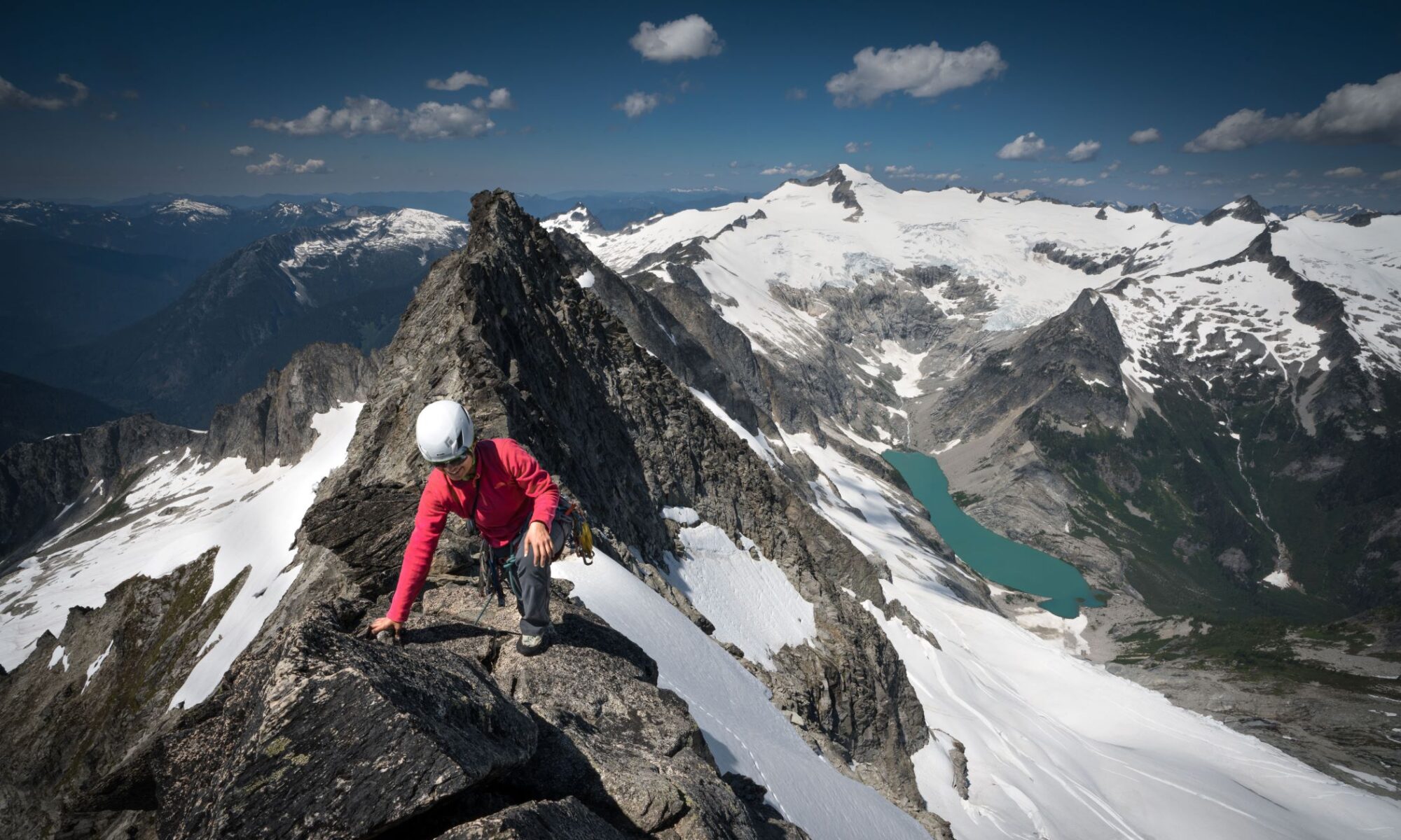
Steve Marston on Forbidden Peak. Photo: Al Papesh. 

by Barry Maletzky

Most of us know about the snow-clad, rugged giants north of Mt. Rainier. Yet, due to distance and a five-day work week for many Mazamas, these giants only rarely appear on the Climbing Schedule. In my opinion these areas, such as the Glacier Peak Wilderness, the North Cascades National Park, and the Mt. Baker/Snoqualmie Wilderness, contain the most spectacular scenery in the lower 48. Blessed with almost too much winter moisture, glaciers abound, cradling gushing streams and waterfalls, feeding the rich volcanic soil, and nurturing gardens of wildflowers seemingly seeded in heaven. These descriptions are written not as definitive guides to access and routes, but to encourage the outdoor enthusiast to seek out these areas off the main tracks we Mazamas so often trod and discover their jeweled treasures.

Sloan Peak (7,835 ft.)

Among these “hidden” gems, Sloan may shine the brightest in terms of Mazama popularity. Ruling in majestic isolation at the western end of the Glacier Peak Wilderness, Sloan’s Matterhorn-like, convoluted appearance belies its relatively benign nature as a climb, at least by its regular route. Sloan’s distinctive horn can be easily identified from most other peaks in the western Cascades, from Rainier all the way to the Canadian border. You may have to get your feet wet crossing a branch of the Sauk River, so autumn is the preferred season for Sloan. A steep approach trail is rewarded by campsites in a secret meadow guarded by rugged towers of stone. The gradual ascent of the Sloan Glacier leads the climber from east of the summit almost, but not quite, around the peak (hence the name of the route as “The Corkscrew”); a usually easy climb up the rocks at the highest western point of the glacier brings one to a surprisingly pleasant meadow stroll through alpine flora to the rocky summit (reached by Class 3 scrambling). Views are handsomely rewarded of the Monte Cristos to the southeast and Glacier Peak just across the river.

Fortress (8,760 ft.)

After a long ride on a dirt track, followed by a 9-mile path tempered by the beauty of magic meadows and surrounding peaks, one reaches Buck Creek Pass, surely one of the most glorious places to camp, especially to catch the fading sun setting over Glacier Peak. On climb day, head north on a climber’s track, then ascend the southwest gardens of Fortress, a secret place you’ll usually have to yourself. (Try to keep the meadow in as natural a state as you can—there are rare flowers hidden here.) Turn north at the ridge and scramble stable talus to the rocky top, where a few rare species of alpine floral jewels remain in bloom throughout the summer. The views encompass all of the Glacier Peak Wilderness as well as the North Cascades Peaks in all their glory.

Colonial/Snowfield Peaks (7,771/8,347 ft.)

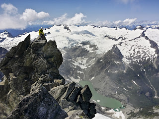
Climber on the summit of Mt. Larrabee, 1.5 miles south 
of the Canadian border (“All-in-all, no finer view can be 
obtained without a rope in all these ranges”) 
Photo: Beau Ramsey.

These jewels, securing the western end of the National Park, occasionally appear on the Mazama Climb Schedule, and for good reason. Once past the trail to Pinnacle Lake, a climber’s path can be followed to a magnificent ridge that offers vistas north and south into snow-covered heights, including Snowking, the mysterious Illabot range, with its pointed pencil of a peak: Mt. Chaval, and grand views northwest to the Picket Range (and Baker and Shuksan). Most parties climb Colonial but an extra day ascending Snowfield broadens the views further and provides a chance to walk one of the most beautiful glaciers in the range, the Neve Glacier: broad, serene and embraced at both side moraines by flowery gardens interspersed with rugged ramparts of multi-colored rock. Both ascents feature glacier travel ending in brief Class 3 rock scrambles. One further benefit: a view into the Teebone and Backbone Ridges, with names to excite the adventurous, such as The Sacrum, The Coccyx, and Lumbar Point, all rarely seen from any easily-reached vantage point.

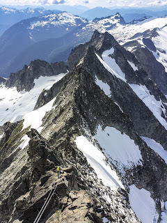
Forbidden (8,815 ft.)

Forbidden bears its name well; although not of towering height, abrupt angular landforms lead, more steeply as you ascend, to a summit tip sufficiently edged to make most climbers dread to tread. However, Forbidden has become an increasingly popular climb due to its east ridge, which goes at about 5.7, and its more frequently climbed west ridge, at about 5.5. It also has the benefits of being in one of the most gorgeous settings for a base camp: Boston Basin. Forbidden’s immense obelisk of rock provides chillingly grandiose views from either ridge, as well as from its summit. All the North Cascade peaks up to Baker are there for the taking, but to my eyes, the sawteeth of Ripsaw Ridge, with countless shards of rock jutting above the immense white sheet of the Boston Glacier and stretching all the way to Mt. Buckner, is one of the most overpowering and memorable sights in any range I have visited in the lower 48. Reaching this summit and making it back down again will provide you with more than hero cred; it will inspire dreams of towers and walls previously unimaginable. This is the closest one can come to Patagonia without leaving this country.

Boston Peak (8.894 ft.)

Steve Marston descending the west ridge 
of Forbidden Peak. Photo: Al Papesh.

Boston is a rarely attempted alternative to the crowded Mt. Sahale; the views are similar to those from Sahale but even more far-flung, ranging from Rainier to the south through the sharpened teeth of the Pickets, and most of the significant mountains in the National Park. Do not be alarmed by the view of Boston from Sahale; appearing from the south as a sharpened vertical shroud, the actual climb is graded at Class 3 with a few stretches of brief Class 4. Aficionados of shattered rock will appreciate the ascent up a well-defined line on the southeast face. A relatively large ridge trends eastward toward a series of chimney and face moves with stable holds all the way to the view-laden summit. While hard hats are a necessity, many parties fail to use a cord, fearful of falling rock. Much closer views of the North Cascade giants will be your reward: Eldorado, anchoring the range to the west, its northern ridge of castellated pinnacles terminating in the massifs of Snowfield and Colonial Peaks; and the steeply angled slopes of Terror and Despair; all backcountry views to be savored by the very few venturing beyond Sahale.

Ragged Ridge (7,408—8795 ft.)

An oft-neglected ridge paralleling the North Cascades Highway west to east, Ragged presents the largest unbroken series of rugged summits outside of the Pickets in the entire North Cascades. Beginning in the west with Red Mountain, an easy scramble from a campsite in Fourth of July Basin, the ridge continues with scrambling on flaky rock. The adventurous party could run the entire ridge in several days, traversing high points such as Cosho, Kimtah, and Katsuk Peaks (mostly scrambles at the Class 3 level). Near its east end, the tallest and best-known summit, Mesachie Peak (Class 4 in spots), pierces the Washington sky with fractured gullies and jagged pinnacles. Most of these peaks can be ascended in a single day from bug-infested camps along Fisher Creek. So why go? To stand on a pinnacle here and there that no other person on earth has ever shared? Yes, but I think it’s the views: seemingly world-wide and ever changing. Rarely would anyone have the opportunity to summit a peak and see the full extent of the National Park, from Goode, Logan and Silver Star in the east, to El Dorado in the west.

Silver Star (8,876 ft.)

Anyone travelling the North Cascades Highway can’t help but be impressed with the hulk of Silver Star, with its jagged tottering towers and gables of rock. This marvel of the eastern part of the National Park area, the highest point in the Methow Range, offers spectacular views of its west and north sides from the multiple loops of Highway 20. A relatively easy single-day ascent is feasible from the highway up the eastern gullies, traversing a glacier then scrambling Class 3 rock. Crampons and ice axe are advised: crossing over to the north face, the glacier can be crevassed after mid-summer and portions can be steep. Views of the Yosemite-like eastern faces of Liberty Bell, Early Winters Spires, and Kangaroo Ridge right next door make the trip from Portland more than worthwhile. In addition, the rarely seen Mts. Azurite and Ballard to the north, and the appropriately-named Needles, sharply incised Cutthroat and Mt. Wheeler, all to the northeast, impress from across the highway. Most parties take an extra day camping at Early Winters Campground and visit the ersatz cowboy town of Winthrop for well-earned beer, burgers and ice cream.

Crater Mountain (8,128 ft.)

Sometimes it feels good, especially for a weekend punter like me, to just meander up an easy peak from a superb campsite and take in the views without having to worry about making it down alive. (Climbers are the only folks I know who celebrate at half-time—you still have to descend!) Right next to the behemoth of Jack Mountain, but absent the drama of hidden crevasses, impenetrable Class 5.9 brush, and the multiple route choices of its fearsome neighbor to the north, Crater is approached by the well maintained McMillan Park-Jackita Ridge Trail to Crater Lake. A base camp on the ridge above the lake provides ample views of most of the North Cascades plus a vista of Jack (which makes you happy you aren’t attempting that convoluted giant the next day). A climber’s path leads across scree and flower-filled meadows until you are presented with a headwall. But not to fear, the way is marked by huge yellow dots painted on the rocks by an explorer anxious to not lose the way; the dots point out the easiest and most stable holds (Class 3 at most). You emerge again upon a sandy plain dotted with alpine flowers and proceed up the climber’s path to the summit. Views are unique: Azurite and Ballard to the east, while Jack dominates as never before, raising its steely heights above the Jerry Glacier. You can spot (and argue about) the many North Cascades summits visible, including Colonial and Snowfield to the west, the Dome group to the south, and the Needles to the east.

Icy Peak (7,073 ft.)

Who hasn’t climbed Ruth Mountain, northeast of Mt. Baker, and exclaimed, “This is the best view for the easiest climb I’ve ever done.” They may be wrong: the view from Ruth’s southern neighbor, Icy Peak, may be even more magnificent (although it cannot be climbed by the average mountaineer in a day and requires glacier gear). From the Hannegan Pass Trail, haul your pack up the climber’s track to some of the loftiest and most view-worthy campsites in all the North Cascades. You’ll probably have time to tarry a bit to enjoy the luscious blueberries (Vaccinium deliciosum—really!). On climb day you may want to tag Ruth’s summit as you pass very near its top rocks. Gently ascend the glacier on Icy’s western front until you are directly south of the three crags comprising the summit configuration. Most folks then choose the western-most of three gullies (Class 3-4) to the Northwestern Peak, but it’s just as easy to scramble to the true high point, the Southeast Summit, by traversing Class 3 craggy rock and one easy gully (hard hats!). Either provides more than the human eye can fully encompass, all overwhelmed by the astonishingly vertical Nooksack Tower, deemed the toughest climb in all the Cascades. The rumble of seracs collapsing into Nooksack Cirque provides a fitting tribute to this ultimate pleasure of the Hannegan Pass region.

Mt. Larrabee (7,861 Ft.)

Larrabee is a long drive from Portland but well worth the trip; it equals Ruth and Icy as the easiest climb for the most stupendous views. This one-day climb begins after a jarring drive past the trail to Mt. Tomyhoi and Twin Lakes, to the High Pass Trail. As the trail heads up toward High Pass, Mt. Larrabee is the reddish summit straight ahead that looks like a loose pile of rocks (it is) shaped like a pyramid. Climbers aim for the white streak standing out from the iron-rich rock and follow it, with its multiple gullies and fields of loose rock, to the talus slope that leads to the summit. Views extend from Glacier Peak in the distant south along with the entire Dome Range, to Baker and Shuksan, then the Pickets and, closer in, the steep American and Canadian Border Peaks, and the incredibly angled rock spires of the Pleiades to the east. Views rarely seen from any other peak south of the border open up to the north: The snows of Garibaldi shine in the distance while closer at hand, the marvelous Canadian sub-range, the Cheam. Perhaps best of all, the fang of Slesse to the east makes one either cringe at its vertical walls or relish its numerous absurdly technical routes (I cringe). All-in-all, no finer view can be obtained without a rope in all these ranges.

Author Bio: Barry Maletzky, M.D. has been a Mazama since 1967 and made a habit of driving to the North Cascades or Olympics almost every weekend from May through October. He has not kept a detailed record of successes or failures at summiting, for obvious reasons, but will admit that lousy weather may have hampered his attempts at certain times. He has, however, worn out a number of vehicles in these attempts.

Thank You: Insert Name Here

by Preston Corless
 
Clockwise, from left: Mark Luscher and Rick Posekany.
Photo: Preston Corless.
This May during the long, slow, cathartic, soul-cleansing slog up one of our local volcanoes, I began reflecting on some of the experiences I’ve had in the past 15 years of climbing. My thoughts moved to the people who have expanded my horizons, pushed me to overcome bigger challenges, and taught me the craft of climbing. I thought about people like Rick Posekany. Within a month, I was shocked and saddened to learn that Rick had passed away.
 
In 2003 I was a young, headstrong climber at the start of my career. I signed up for Posey’s climb of Aconcagua, the highest peak in South America. I was in over my head, even more than I realized at the time. 
 

Soon after arriving at Plaza de Argentina base camp (just under 14,000 feet), I started feeling lousy. Really lousy. Rick took me to see the camp doctor, who confirmed what Rick suspected—I had acute mountain sickness. They put this little contraption on my finger, which recorded the oxygen saturation of the hemoglobin in my blood. While at sea level this would read around 99 percent, but at that time it was in the low 80s, which somewhat explained why I felt about half as good as normal. Imagine a bad hangover with a dose of heavy lethargy. I was physically, mentally, and emotionally wrecked. I was 20 years younger than the other guys, and yet I was the one who wasn’t going to make it anywhere near the summit. I had a deep, sinking feeling about all the time and effort that I had committed to this trip–for naught.

They started me on Diamox and told me to rest. In his gruff, terse, gentle way, Rick kept tabs on me and told me not to give up hope. The next day Rick, Mark Luscher, and John Peters carried loads to camp 1 while I rested. The following day the pulse oximeter read 88 percent. I was feeling better and cleared to keep ascending. We moved on to camp 1, then camp 2. I moved a little slower, humbled by my own frailty. We got pinned down by a bad storm at camp 2 for six days, testing our patience, supplies and determination. We had carried a load to another camp called Piedras Blancas, at about the same elevation but closer to the ascent route. Nearing the end of our allotment of time and supplies, the weather began to clear. We scrapped our plan to move; instead Rick and Mark retrieved our cache of gear from Piedras Blancas. It was a short, flat traverse, but the wind was such that they had to break trail through the snow both ways. 
 
(Willy’s wagon) is on the approach along the
Rio Vacas.  Photo: Preston Corless. 
The skies opened and camp 2 turned into a bustle of activity as nearly everyone mobilized for the summit. After so much bad weather and luck, I could hardly believe we were actually headed out. It was an incredible day—dark, blue, cloudless skies and no wind—and hard to believe after the weeks we’d spent there. On Aconcagua the wind is a nearly constant challenge. It blows tents away. You can hear gusts coming, like an airplane. It is visible in the form of lenticular clouds–the viento blanco. I was getting used to the cold, the wind, not eating enough, and hanging out in those stinking tents reading Atlas Shrugged
 
Rick was exhausted from breaking trail to get our boots and supplies from Piedras Blancas. The trail out of camp 2 was deep with snow. The day seemed long as the sun cut through the high, thin air. 
 
The final approach is a dusty slog. We labored slowly up the slope, fighting the thin air. Rick was unselfishly carrying a lot of group gear–first aid, extra food, extra gloves and so on. He was falling off the pace. I waited for him; we fell behind the pack. After many, many rest stops I finally convinced him to switch backpacks with me. There was no way I was going to the summit without Rick. After all the extra work he had done for the team, I would not have made it without him; I would not have earned it.
 
Our pace picked up a bit with the weight redistributed. As we climbed higher, the views opened to the northwest, west, and southwest. We reached the summit around 7 p.m. and spent all of 15 or 20 minutes on top, after two weeks of hard effort. Coming down the sunset was pretty amazing. Rick and I didn’t make it back to camp until after midnight. It took us 19 hours to climb 4,000 feet. 
I had never felt so physically and emotionally exhausted. I can’t say I was elated that I summited, although I know I would have been disappointed to come all that way, put forth all that effort and expenditure, and never make it past Piedras Blancas. More than anything I felt a great sense of relief about not going home empty handed.
 
Rick and Preston on the summit. Photo: Rick Posekany.
Together we made it to the summit. That climb taught me a powerful lesson–that climbing is a team sport. Life is a team sport.
 
The things I learned on that climb helped form the foundation of my climbing experience. We talk about climbing in terms of mountains, cliffs, routes, grades, ratings, buttresses, glaciers, faces and couloirs. New climbers quickly accumulate the latest, most-improved gear, mileage, summits, and routes. With maturity we begin to appreciate more and more the importance of partners and community to the climbing experience. To quote Gaston Rebuffat: “The choice of companion is as important as the choice of the climb.” As specific climbs fade in memory and significance, the bonds forged between partners only become more meaningful—and transcend the climbing experience. 
 
Very soon two of my other mentors will be heading out on an epic adventure. They have motivated and inspired me to be a better climber and a better person. Our mentors are not always older or more experienced.
 
Wherever you are in your journey of life, stop and take a moment to reflect on who your mentors have been, and how they’ve influenced your life. Thank them, and pass it on.

Mt. Cruiser Climb: A Rare Sighting

 
by John Rettig
 
It’s not on every Mazama climb that you get to summit a mountain AND encounter a rarely observed animal.
But that’s exactly what happened on June 20, 2015, when seven Mazamas stumbled up Mt. Cruiser in the Olympics’ Sawtooth Range with me.

It was a good reminder that while summit views are almost always spectacular, the things that happen on the way to the summit can be just as spectacular, if not more so.

 
Mt. Cruiser Needle.
Photo: Glenn Widener
Our group had just stopped for a break, when a little critter suddenly popped out to have a look at us. We were sitting in a rocky area above the tree line between The Needle and Mt. Cruiser. (The exact location is being withheld, in agreement with the US Forest Service (USFS) and National Park Service (NPS) scientists, to protect the individual marten). At first, I dismissed the animal as just another marmot or pika. But after a second, more careful, look, I recognized the narrow-set binocular eyes and very slender build that characterizes members of the weasel family. That the animal was extremely curious about us and our activities, and generally was not particularly wary of our presence, was another indicator that this critter belonged to the Mustelidae family.
 
The size of the animal suggested it was a marten or fisher, and after some group discussion, we realized we were probably looking at something quite rare. I knew that sightings in the Pacific Northwest have been very rare for any of the Martes genus, as they are known to live at a very low population density, even within their normal range. But this marten was living at the extreme of its documented range. So the sighting was doubly significant. Fortunately, one member of our team, Shem Harding, had his camera ready and was able to take several photographs. We also took note of the marten’s behavior, which included a breathtakingly exposed four-foot jump. We marked the GPS waypoint, then carried on with our climb. When we returned to Portland, I quickly submitted a report and pictures to the USFS, not knowing if there would be any follow-through.
 
How rare was this sighting? On the Tuesday following the climb, within a half hour of the report reaching the NPS and USFS wildlife scientists, my email inbox ignited with descriptions of how meaningful our sighting was, along with kind words of thanks for documenting and reporting it.
According to Dr. Patricia Happe, Wildlife Branch Chief at Olympic National Park, “Neither I nor any of my crew is likely to go near [Mt. Cruiser]—we are all hikers, but no one is a climber—maybe that is why we have not been finding any marten after all these years of looking …The last verified sighting of a marten in our region was in 2008 near Mt. Rose … [And then] the fisher study JUST (June 3, 2015) picked up a marten in the upper Hoh Valley. Your sighting [on top of this one] near Mt. Cruiser, in a completely different area, is really exciting.”
 
Betsy Howell, Wildlife Biologist with the Olympic National Forest wrote, “We have been trying for many years to get information on where marten are residing in the park and forest and haven’t had much luck … Olympic National Park and National Forest, along with Washington Department of Fish and Wildlife and U.S. Geological Survey, are planning more marten surveys this winter and we’ll be having a meeting soon to discuss. We’ll definitely be talking about your sighting.”
 
The lesson that our marten sighting drives home for me is just how extremely important it is that we all act as responsible stewards for the alpine areas that we love. This encounter is an example of yet another way we can manifest that stewardship. Buried in the email clamor in my inbox was the suggestion that future studies might be able to take advantage of the Mazamas frequent access to the rocky summit areas above tree line. We’ve since prevailed upon other climbs headed into the area to be on the lookout and to observe and record. 
 
Learning how to observe and photograph animals in the wilderness, especially for gender identification, and recording GPS coordinates and gathering scat samples for DNA and other studies will help scientists evaluate the diversity, diet, and health of a given population. Reporting any marten or fisher sightings on the Olympic Peninsula will further this important work. You may submit information about a sighting or request a training by sending an email to conservation@mazamas.org.
 

Pacific Marten: The Facts

The Pacific marten, Martes Caurina, is a rarely seen mammal in Washington’s Olympic National Forest. It is a carnivore from the Mustelidae family, which includes wolverines, badgers, otters, skunks, minks, martens, fishers, weasels, and ferrets. Because it was heavily trapped from the 1890s through the 1940s, it was nearly extirpated. In spite of formal winter studies conducted from 2001 onward, there have been only four verified sightings in 27 years. In 1988, one was seen alive and photographed near The Brothers Wilderness; a spotted owl study found two in a live trap in 1990 in the Buckhorn Wilderness (they were released); in 2008 a deceased juvenile Pacific marten was found by hikers near Mt. Rose; and in 2015 one was photographed in the Hoh Valley with an automated wildlife camera, as part of a fisher study. Our discovery—during a Mazama climb up Mt. Cruiser in June 2015—now brings the number to five verified sightings, and the first one in 25 years to be seen alive in person. 
 

In spite of significant efforts to locate and document the Pacific marten (the 2013-14 winter study involved 15 volunteers working 12 different days, which equates to 78 working days) the studies did not yield any martens (although they did result in documenting a rich and diverse wildlife population of cougars, bobcats, coyote, deer, elk, and yes—humans and domestic dogs). We have, in fact, encountered wolves in Oregon more times than we have martens in the Olympics—and we know there are only 77 wolves in nine packs in Oregon, as of the end of 2014. The contrast is quite stark!

Emotional Atrophy Amid the Revelations

The Revelation Mountains are a small, rugged subrange of the Alaska Range located about 140 miles northwest of Anchorage and about 130 miles southwest of Denali. The principal peaks are granite spires that rise out of relatively low-elevation glacial valleys. The high vertical relief of the Revelations creates a dramatic backdrop for some very challenging climbing conditions. They remain mostly unexplored because the weather is notoriously heinous and the flight to get there is long and expensive.

None of this has deterred alpinist Clint Helander, who made his eighth trip to the Revelations with help of a $1,000 grant from the Mazama Expedition Committee. 

The objective for his eighth trip? The tallest unnamed peak in the range, known simply as “9,304.” 
“Words cannot describe the beauty of this peak,” Helander said in his grant application. Helander planned to climb the Southwest Buttress of Peak 9304, a 3,500-foot route, in a single push of 24 hours. 

What follows is his account of the ascent.

by Clint Helander (all photos are courtesy of the author)

There would be no sleeping on this night. Last evening’s -25 degrees Fahrenheit freeze had given way to warmer temperatures, blown in with a ferocious storm. I knew my climbing partner, Tad McCrea, was also awake, but we said nothing. We just laid there in silent fear and listened. The wind moaned a slow, agonizing cry among the summits and lenticular clouds. Then, like an army of charging demons, it screamed down the valley, gaining momentum and strength as the surrounding walls tightened. 

Like counting the growing waves on a shoreline, we began to determine when the biggest of the gusts would hit. Despite our snow walls, they seemed to blow right through us. Our four-season tent would flatten, the fabric stretching and poles creaking. “We’re not going to make it through the night,” I thought. Like a captain talking to his battered ship amidst a tempest, I begged the tent to survive. “Hold strong,” I quietly pleaded.

This wasn’t what Tad and I had planned on when we landed under perfect skies the previous day. But now, in the northern heart of Alaska’s Revelation Mountains, we felt alone and adrift. I braced my side of the tent through the most terrifying of the gusts and began stuffing all of my loose belongings in bags. “Should I put my boots on,” I wondered? “She’s going to break at any moment.”

March’s early morning twilight began to eek through the sagging tent walls. So far, she had weathered the storm. The winds began to ebb, now gusting to perhaps only 80 miles per hour. Our snow walls were gone, the glacier scoured into a shadowy white and gray wasteland. I emerged from the vestibule in full war regalia. We dug all day, excavating a snow cave under the flat glacier. We couldn’t survive another night of wind like that without it.

The brunt of the storm passed, but ceaseless wind followed for another five days. We resigned ourselves to passing the hours in our tent and snow cave, emerging now and then to snatch a few glimpses of our distant prize: the unclimbed monolith labeled “Peak 9,304” on our Lime Hills USGS topographic maps.

Tad was running out of time–the pilot would be there to pick him up in less than 24 hours–and the wind had yet to subside. We called for a weather update. It would be calm the next day. We awoke at 4 a.m., but the incessant wind persisted. We rolled over and tried to sleep, but the sound of our enemy outside refused to let us kill more hours in slumber.

At 11 a.m. the wind finally blew away. We skied out of camp in rapid procession. The south face of Peak 9,304, a mountain I had long referred to as “the Obelisk,” held its triangular form as we approached.

A snow-filled chimney held my picks, but threatened to spit me out. My protection far below felt suspect. Sixty meters above, a grainy crack offered a decent spot to anchor in. Tad led a long block of simul-climbing to the base of an ice-streaked headwall. A prow reared out past vertical and the hanging daggers looked almost impossible to climb. The summit was many thousands of feet above us still. We retreated.

Tad reluctantly flew out the next day, and in his place John Giraldo arrived, fresh and unbeaten by the storms. We quickly reached our highpoint on the Obelisk. I searched for courage as I confronted the looming ice above. A bad screw penetrated snow and aerated ice, then a few feet higher a good, small cam. “Watch me, John. This is really hard and scary,” I muttered. My tool shuddered and reverberated as it penetrated nominal ice and struck the granite slab underneath. A deep breath and I trusted myself to it. Another swing and a wide stem and I was still moving upward. I swung again, only this time the tool broke through the ice and into air. A two inch crack! Hanging there, teetering on my loose pick, I excavated the crack and placed a dreamy cam. The crack continued for another fifteen feet of salvation. Seventy meters of difficult climbing continued and I searched for an anchor as the rope came tight. Small cams shifted in odd-shaped cracks, and pins bottomed out in seems. John followed and I studied the anchor while I thought about him on the crux moves.

We continued upward for hours in long blocks of simul-climbing. The absent wind seemed strange on our sunburned faces. We approached the summit in the afternoon, high above most of the surrounding Revelation peaks. At the top, I thought back to the stress of the previous week of fighting the endless winds. I pushed the pain of a failing relationship from my mind. Two words came silently to the front of my mind: emotional atrophy.

On the summit though, it was a brief moment of long desired tranquility.

Clint Helander started climbing in 2003 and has climbed a variety of alpine routes in Alaska, including an integral ascent of the Moonflower on Mt. Hunter and the third ascent of Mt. Huntington’s Phantom Wall. Yet, he returns to the less explored Revelations every year to seek solitude and adventure. It is those experiences in the true wild that mean the most to him.

Over the years, Helander’s trips have culminated in six first ascents and two first ascent routes on mountains that had only seen one prior ascent:
  • 2008: First ascent of Exodus Peak (8,380 feet)
  • 2009: First ascent of Ice Pyramid (9,250 feet)
  • 2011: First ascent of Mt. Mausolus via Mausoleum (4,400 feet, WI5)
  • 2012: First ascent of Golgotha (8,940 feet)
  • 2012: First ascent on the South Ridge of the Angel (9,265 feet)
  • 2013: First ascent of Apocalypse via 4,200-foot West Face (WI5 M5)
  • 2014: First ascent of West Face of Titanic (3,800 feet, M6 5.8)
  • 2015: First ascent of the Obelisk (Peak 9,304’) via Emotional Atrophy (Grade 4 M6 WI5 A0 3,280’) on the South Face. Clint Helander and John Giraldo, March 22, 2015.
This article was initially published in the 2015 Mazama Annual. All rights reserved.