From Polluted Air to Thin Air: Thorong La Pass Nepal

by Ananda Vardhana

Traveling from Portland, we landed at Tribhuvan International Airport in Kathmandu, Nepal on September 24, 2018. Ten of our group headed off to Annapurna Base Camp (ABC), but the remaining three of us had set our sights on Everest Base Camp (EBC) at 17,598 ft. Our team was comprised of Deepa, an ultra-marathon runner, Anil, an intermediate hiker, and me, Ananda, a 62-year old veteran hiker and Mazama member.

Stepping off the plane in Kathmandu, we were engulfed in the pollution, dust, and chaos of a typical Nepali traffic jam. Only the promise of thin, clean, Himalayan air kept our spirits high. When our flight out of Lukla was canceled due to bad weather, forcing us to abandon our goal of reaching Everest Base Camp, our consolation was to hike even higher than EBC over Thorong La Pass (17,769 ft. ) along the Annapurna Circuit.

Our guide, Mr. Khim Raj (KC), proposed a new trekking plan that started in the town of Besisahar at 2,493 ft. and slowly wound its way up to the pass. Starting at a lower elevation would allow us to acclimatize as we passed through other villages along the route, including Chame at 8,694 ft., and Manang at 11,545 ft. However, we were familiar with hiking at lower elevations in Oregon, and insisted on starting in Manang.

Once we’d determined our starting point, we took off on the 12-hour, 107-mile drive to Besisahar. Kathmandu is famous for its traffic jams, which dwarf those in LA, and these roads were bad! The following day, we had to take multiple 4-wheelers and drive another 12 hours between Besisahar and Manang along some of the world’s most dangerous highways. Due to frequent landslides, our two porters had to carry our luggage across the debris and hire another jeep on the far side before we could continue. I would not recommend going without a guide—they know these roads and allow for safe passage.

From what I saw, Nepal is very community-oriented. The people are friendly and help each other survive. Since the three of us know Hindi, we made good friends during our multiple jeep rides. The jokes, bantering, and singing inside the vehicle combined with the astounding views and narrow roads outside helped us forget the dust that enveloped us.

Thus, after multiple landslides we reached the thin and pristine air of Manang. This meant we’d essentially gone from Beaverton at 120 ft. to Manang at 11,500 ft. in one go. We’d been swallowing Diamox (altitude pills) since arriving in Nepal, 125mg twice a day. At Manang we could feel the effect of the thin air, but this was what we wanted. Just walking 10 steps let us know we were at high altitude. Our appetites shrunk greatly, but we nonetheless pushed ourselves to have a grand dinner followed by a fitful sleep.

A long time ago, when trekking was not a fad, people lived their lives in all parts of Nepal and the surrounding region. As trekking became popular, the local people realized the potential tourism could have and converted their homes to teahouses. Now villages, including Manang, have 2-3 star hotels with hot showers and comfortable beds. You order from a menu and can even get pizza at 16,000 feet! And Wi-Fi is available all over Nepal.

The next day, KC advised us to roam round Manang and get acclimatized. Manang valley is like a dreamland. In Nepal, many of the mountaintops have a Buddhist shrine. It is amazing what faith can do. People have built massive structures on the tops of mountains where every stone and beam had to be carried up manually or by horse. Our hotel in the valley looked up at the Annapurna Massif on one side followed by Gangapurna. In the distance towered Manaslu, Chandragiri, Dhaulgiri, and Chluha. We saw these titanic mountains for the next ten days; they astounded us with their unbelievable massiveness. In Oregon, looking down from Mt. Hood or Mt. Defiance, the rolling mountains fascinate us—so just imagine mountains twice the size of Mt. Hood! All of them over 20,000 feet, with live avalanches happening as you watch… such was the grand spellbound beauty that beheld us daily.

Early in the morning with high spirits, we took off from Manang. Our plan was to hike to Ice Lake at 15,256 ft. the first day, followed by a hike to Tilicho Lake at 16,138 ft. the second day, then continuing on to Thorong La Pass. The route to Ice Lake has no designated switchback trail, so we simply had to climb straight up a crumbling mountainside. Being the oldest, the altitude and strain from hiking hit me fast. Deepa and Anil encouraged me, slowing to my pace so we could crawl up together. Deepa and I were going steady, but Anil, who had a slight residual cough when we left Portland, began to slow down. Anil’s occasional cough became persistent and much stronger as his lungs tried to keep up in the thin, high altitude air. We were three-quarters of the way to the lake, at around 14,800 ft., when Anil started getting breathless and feeling slight lung pain. He decided not to push it any further, fearing AMS (Acute Mountain Sickness) or worse, HAPE (High Altitude Pulmonary Edema). I decided to escort Anil back down to the hotel along with a porter. Deepa continued to Ice Lake with the guide, and joined us back in Manang a few hours later.

That night, Anil could not sleep well due to breathlessness and coughing. I intently kept an eye on him, hoping the night would be uneventful. We consulted a couple of doctors by phone, spent some time researching on the Internet, and finally decided that he needed to head back to lower altitudes. That broke our spirits—it was sad to see our partner off, but we would meet him at the end of the trip.
Deepa and I re-strategized, deciding to abandon our hike to Tilicho Lake and instead just do Thorong La Pass. The pass was three days away and should give us ample time to acclimatize. The next day, we trekked from Manang to the village of Thorong Phedi at 14,895 ft. No one measures the distance of a trek in Nepal. If you ask, they will look at you, then make a judgment and give you an estimate in hours. This trail was gradually uphill and took us 5-6 hours. It was quite busy with people from all parts of the world. Germans by large dominated, followed by Australia, China, New Zealand, and the UK. Much to our disappointment, we didn’t encounter a single hiker from the US, our adopted country, or from India, our country of origin.

Hundreds of yaks dotted the mountainsides. Nomad yak herders live at these great heights sleeping out in the open. They drink yak milk, eat yak meat, and warm themselves with coats made of yak hair. Right in the middle of the trail, we were surprised to see a roadside trinket trader. The old man claimed all his goods were authentic Tibetan. The yak herders, trinket traders, and brave people who tend the tea houses make it possible for us from the polluted air to survive up in the thin air.
By the time we reached Thorong Phedi, Deepa had lost her appetite, and we both had splitting headaches. However, we had increased our Diamox dosage to 250mg twice a day. We didn’t want to take any pain medication because our stomachs were empty, so we just applied a strong topical ointment called Tiger Balm onto our foreheads and bore the pain. I am a strong advocate for fewer pills and more will to fight altitude sickness.

The next day, we made the grueling climb from Thorong Phedi to Thorong High Camp at 16,010 ft. Deepa, who had little appetite, started to feel weak and nauseated. At Thorong High Camp, we realized the real scarcity of oxygen. We had hiked in India at 15-16,000 ft. without much trouble, because the forest abounds everywhere. Manang valley is totally arid, a dry high-altitude desert with no trees for generating oxygen.

The moment Deepa entered the dining hall she began to feel nauseated. Two hundred or so lungs and five open-flame kitchen stoves all competed for the oxygen. So our choice was to stay warm and suffocate, or go outside and freeze! Sitting here in Beaverton, these things cannot even be imagined. Our guide said we had three options; head back to the city, stay where we were at Thorong High Camp, or continue on but take a horse as insurance. We went for the third option without even considering the first two, and hired a horse for $150. At that point, we didn’t know who would need the horse—Deepa or me.

Since the winds pick up by noon and can practically pluck you off the mountain, we had to leave before 5am to cross Thorong La Pass by noon. Thorong High Camp has minimal accommodations—five common toilets for two hundred or more people. So, with splitting headaches and anxiety about using the toilets, we hardly slept, got up at 3am, and were ready by 4am. With the horse following dutifully behind, we put our heads down and started the final phase of our climb. Every 100 feet KC would ask “Deepa-ji, would you like to take the horse?” to which she would answer “no.” He was afraid she would fall off and increase his responsibility. At 60+, I go very slowly but steadily, and kept up a steady stream of encouraging accolades. Deepa’s only job was not to lose the sight of my heels.

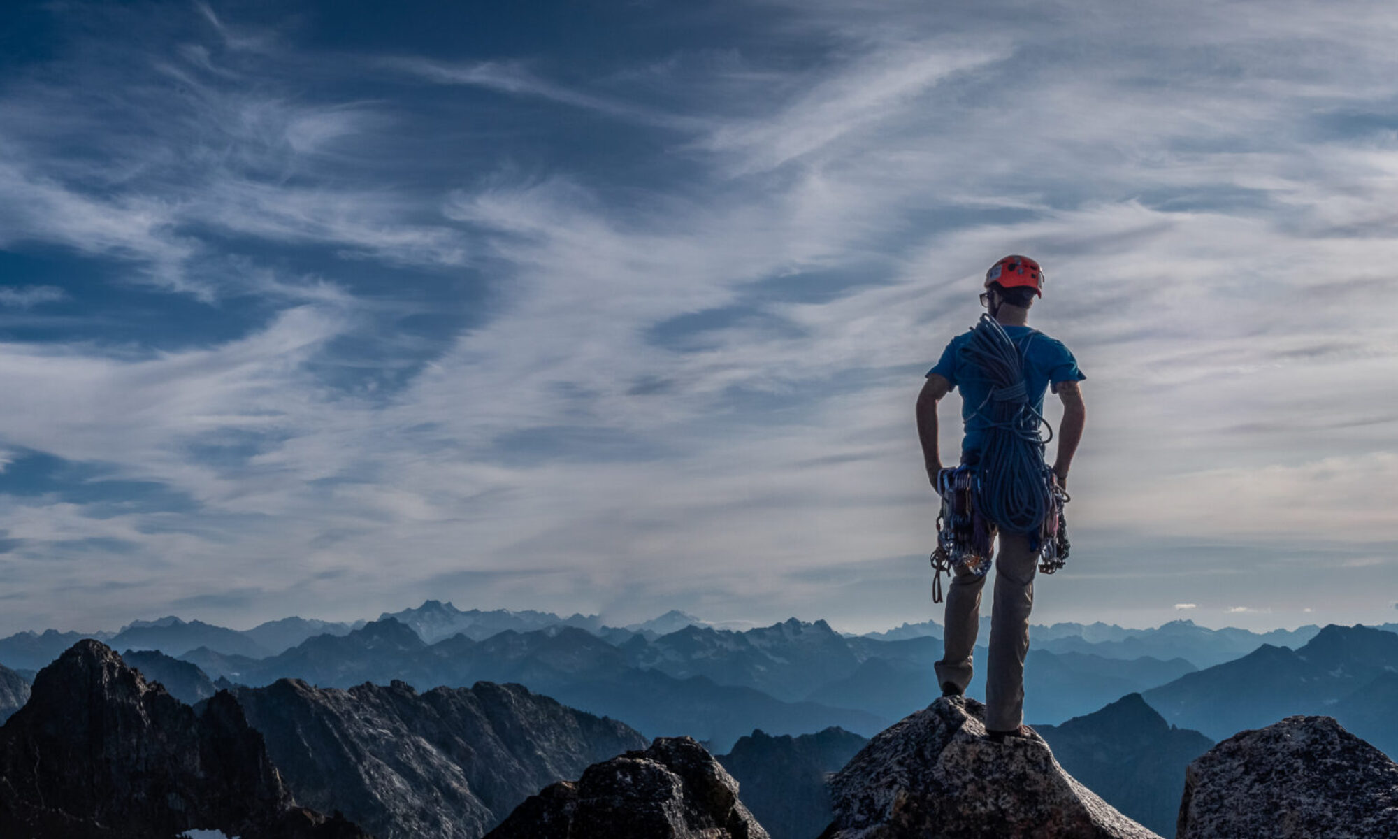
Neither the words I’m writing nor the camera on my phone can capture the dry beauty that surrounded us. The trail disappearing into thin air was what we had hoped to conquer. On any hike, there are always people well ahead of you and others far below. The people ahead represent the goal yet to be achieved, and those below are the challenges conquered. In the end, it all depends on the mind to push the mechanical devices we call legs to move one step up at a time, up and up.
Finally, in the distance, we could see the colorful streamers that decorate the pass. With a fresh surge of energy and enthusiasm, we chugged on. Deepa, the ultra-marathon runner, crossed the finish line at a full sprint, as I slowly crawled up to the top of the pass. From there, it was a rollover hike, down and more down, to Muktinath Temple at 12,171 ft.

We stayed in Muktinath that night, and drove the next day to TatoPani (6,010 ft.), which is famous for its hot springs. After an overnight at TatoPani and a refreshing bath in the hot springs, we trekked up to the village of Chitre at 6,988 ft., were we stayed one night before making it up to the village of Ghorepani at 9,429 ft. the next day. The Ghorepani Poon Hill overlook is a famous scenic spot, and is flooded with trekkers. Since we’d been immersed in Annapurna I, II, III, Dhaulgiri, and many other mountains, we skipped Poon Hill. The final day, we trekked to Naipaul, where the ten Annapurna Base Camp folks joined us. We all drove back to Pokhara, met up with Anil, and flew back to Kathmandu—back into the polluted air! We ended our trip by flying back to Portland on October 8.

First Crack: Ice Climbing in Lillooet, BC

by Wendy Marshall

While my family was neither wealthy nor outdoorsy, I’ve always had a passion for being in nature. As a result, I easily landed in Geology studies at Western Washington University, yet “extreme” sports like snowboarding still felt as distant as Mars despite my PacNW upbringing. That changed the day I spotted a weekend trip posting on our Outdoor Club board. Lillooet Ice Climbing, it said. As a figure skater who hoped to work in Antarctic science, I already had a deep love for ice—but ice climbing? A little research, and I had the facts. This wasn’t just any ice-stomping, but straight-up frozen waterfalls. One of those sports. Here was my chance, to enter a world of edgy skills, glossy magazines and pure alpine adventure. I knew I had to go. After paying the fee and tooling up on boots, axes, crampons and clothes at my very first used-gear sale—my head bursting with brands from Charlet-Moser to Grivel, and terms like monopoint crampons—I was ready.

On February 12th, eight of us plus Ryan and Dave, the young but competent leaders, piled into the vans and set off. A hub of interior British Columbia, Lillooet is a tiny place whose economy still utilizes extractive industries like logging and mining. It also offers some of the best vertical ice terrain in the area, plenty of it easily accessible by road for short excursions. First, of course, you have to get there. We wound deep into the Canadian Rockies on the Trans-Canada Highway, passing towns with names like Hope and Spuzzum, and by the time we reached Hell’s Gate—a thin, sketchy red bridge and air tram swaying precariously above the little river that thundered through rocky Fraser Canyon—we felt alike nervous, excited and surreal. Our target destination: Marble Canyon, barely an hour north of Lillooet.

Marble Canyon shelters clusters of frozen waterfalls, which we could see from the road, clinging to rock faces between ridges of snow-dusted conifers. We craned to look, our necks cricking. Then suddenly we arrived. Grabbing our mix of owned and rented gear, we hiked a short way across the frozen Crown Lake, up a slope to a popular family of icefalls, crowned by the famous 3-pitch route named Icy BC.

This group offers routes rated WI3-6, from fat chunky well-bonded ice columns, to thin glaze mixed with bare rock and hanging sheets. Saving Icy BC for later, we started from the left, at the broad Deeping Wall. Ice climbing with a group, I learned, is great fun and camaraderie, but you also stand around waiting. A lot. Nervously, if you’re a rookie. I picked up what tips I could, befriending Allison and Jen and the rest of our team. We watched Ryan and Dave climb to set up topropes, inserting ice screws as they went. The first volunteers followed, and cries of “Ice!” “Ice!” (or in the case of Andrew, a Brit, “Oice!”) rang out whenever somebody knocked loose any sharp ice chips or plate-sized “death cookies” with axe or crampon, at which we ducked our helmets.

But nothing compares to that virgin attempt at a new skill. Everyone was so encouraging, and I tried to feel reassured by the tug of the toprope at my waist, when I’d never even climbed with a toprope on rock. Soon, my forearms were burning. Tiny ice chips stung my face and plinked off my helmet, as the wicked-looking recurved technical axe I’d proudly purchased ricocheted maddeningly off the rippled blue ice time and again. Now I couldn’t get a foothold—what was wrong with me? My crampon had popped off my foot! Time to descend. I felt a bit discouraged, weak and clumsy, not to mention sweaty, my pumped arms like jelly. Back to waiting and watching in the cold. But it was hard to feel sad for long in such a beautiful place. I got a sweet photo of Allison and Jen hugging for warmth, grins and pink cheeks and nose-ring barely peeking out of cozy winter woolens. Then I wandered over to look at a stunning pillar of ice that emerged magically from beneath an overhang, creating a glowing cave of translucent blue like a temple of ice. Crawling in, I felt awed and exhilarated.

That night, we camped in tents, in the coldest night I’d ever faced. One by one, we drifted from the cheerful campfire, filled by a tasty dinner of sloppy bean stew, and to bed. The thermometer dropped to 10 degrees F. Morning came, and the last thing I wanted was to poke more than my nose from my sleeping bag, but I knew I’d be warmer moving. I couldn’t feel my foot, so I shoved it hard into my boot, heard a crack, and thought, “Oh well—I might’ve broke a toe, but I can’t tell!” (I hadn’t.)
Over the weekend, I learned valuable techniques from our leaders, which we practiced between climbs. A bent-kneed “monkey hang” from extended arms will save them from fatigue. Coupled with the hang, wrist straps offer added support when your grip becomes tired on the ice axe. Using the weight of your lower leg pendulum-style, kick straight in, drop your heel and try not to wiggle your foot. Aim for the pockets of dense-looking blue ice between the lighter-colored prominent bulges, which are often highly aerated and/or fractured. But the greatest feeling came from a properly-executed swing of the axe. After being shown how to line up my shoulder, elbow and wrist to transmit the force of my swing with maximum efficiency, the serrated pick sank home with a solid, satisfying ssthunk. Chills flew up my spine. “Yeahhh,” Ryan growled, to cheers from my teammates.

On the third day, we hiked a bit further to a beautiful route called Cherry Ice, where victory found me at last. My axes landed solidly more often than not, and my hands and feet found their rhythm: Thunk-thunk, followed by the chip-chip-chip of crampon steps. My teammates grew tiny below. Too stoked to stop, I rounded the waterfall’s sloping crest until the rope topped out, then looked out at the amazing view. I felt fantastic, wishing I could climb again immediately. But as I handed off the rope at the bottom, a tiny ice chip whizzed by and cut my ungloved hand, as if to say: “Don’t get too cocky, now!” I felt the respect, but my joy was undiminished. The others shared my sentiments. “We chopped this to s—,” one guy said happily. Then all too soon, we were leaving, me sitting next to Dave as the van pulled away, and by accident we broke into the same song at the same time: “On the road again …”

A few years later, this same trip was again offered. Then I would climb Icy BC itself, stay at the Mile 0 Hotel, and try the notorious Figure-4 move just for fun. Since moving to Portland, Oregon, I’ve discovered the Columbia Gorge offers some exciting water-ice possibilities, while the Mazama Center’s new ice climbing wall provides a place to work on techniques. But I will always treasure my first ice climbing trip, most of all for what it represents: The courage of trying and the joy of being.
Wendy Marshall found the Mazamas in 2014. She loves herbs, nature, and mountain sports, and supports the latter through a budding career in writing, aided by a steady supply of Fig Newtons and dark chocolate during rough stretches.

Iditarod 2018

Anna Berington, 22nd finisher, approaches Nome. Photo: John Richards.


by John P. Richards

We finally saw some movement on frozen white landscape and sky. From a distance, it appeared to be a team of reindeer hauling an abominable snowman. As they came closer, it was clear that Nicolas Petit and his team of dogs had arrived at the White Mountain checkpoint. Petit was the second musher into the checkpoint, just behind leader, Norwegian, Joar Leifseth Ulsom, who slept soundly while waiting out the mandatory eight-hour rest stop. Petit looked dejected as he settled in and fed his dogs. His dogs looked dejected too. Dog teams sense their musher’s emotions. Highly trained and intelligent athletes, they know where they stand. A day earlier Petit was cruising through the race, in the lead with a nice margin ahead of Ulsom. He lost the trail marker in a storm and fell four hours behind, arriving now in second place.

Jessie Holmes, Rookie of the Year, thanks
his team at the finish in Nome.
Photo: John Richards.

My wife turned 60 years old in March, and it’s been her dream to see the Iditarod. That made choosing a special gift very easy—a trip to Nome, Alaska, to the finish of the 2018 Iditarod. We connected with Laurent Dick, a local guide and photojournalist, to help us get deep into the race, festivities, and provide an insider view.

The Iditarod is a dog sled race from Anchorage to Nome, spanning 1,049 miles, and held annually in March since 1973. The race was inspired by the 1925 Serum Run, a dog sled relay that delivered much needed serum to Nome, to help stop a deadly diphtheria outbreak in the winter of 1925. No other means of transport could deliver the serum to the isolated town fighting extremely low temperatures and blizzard conditions. On February 1, 1925, musher Gunnar Kaasen and his dog team arrived with the lifesaving medicine. Many lives were saved that winter. Kaasen and his lead dog, Balto, became instant celebrities.

We had taken a small plane from Nome to White Mountain, a tiny village on the Seward Peninsula with about 200 inhabitants and 77 miles from the finish in Nome. This checkpoint is an ideal location to catch a glimpse of the mushers and their teams as they move toward Nome. A large percentage of the residents were out in the cold air and light snow to see the leaders arrive. That large percentage is still a relatively small number of spectators making the race a very intimate, accessible, and transparent sporting event. It was very easy to get up close, talk with the mushers, and interact with the sled dogs. The checkpoint is entirely managed by volunteers as is much of the race logistics and activities. Most of these volunteers are veterans, returning year after year, not able to resist the annual call of the Iditarod Trail.

We headed back to Nome after the arrival of Mitch Seavey, pre-race favorite and, between he and his son, Dallas, had won the Iditarod every year from 2012. Last year, 2017, several of the Dallas Seavey dog team tested positive for the banned substance, tramadol. The musher was not penalized as proof could not be found that Seavey intentionally had given the dogs the substance. Dallas Seavey has strongly denied the incident and boycotted this year’s race in protest. The 2018 Iditarod was not to be a Seavey win, as Mitch sat it third place at White Mountain, too far back to be a serious contender.

Anna Berington sled dog at finish in Nome.
Photo: John Richards.

It was bitterly cold in Nome at 3 a.m., March 14, as the red and blue lights of the Alaskan Trooper announced an approaching team from the far end of Front Street. A police escort guided Ulsom and his team over the last mile, arriving to victory under the Iditarod Burled Arch. Spectators had come out from a short night’s sleep or staggered out of the many local dive bars lining the final stretch. As Ulsom kicked in the sled brake, he looked exhausted, but his dog team looked fresh. The bright lights of cameras and chaotic set of dog handlers, race officials, and media surrounded the winner. Heavy breath hitting the extreme cold rose above our heads, a mystical vapor framing the scene. This is not a rich event. The winner takes home $50,000 and a new truck. That doesn’t cover the typical investment needed to race. The mushers are not here for the money. They race for passion, pride, love of the sport.

The crowd called out to the winner, congratulating he and his dog team. The dogs, who many know by name, receive as many accolades as the mushers. These dogs are the engine that drives the musher to the finish. The lead dog, tactically finding the trail, motivating the others, piercing wind, snow, and cold, dutifully finding the finish line. Another group lined along the finish were holding signs in protest, PETA, People for the Ethical Treatment of Animals. A few shouting matches could be heard among the crowd, two opposing opinions, fans and locals in full support of the race and its athletes, mushers, and dogs, the other in protest. Whether it was the dead of night, the freezing cold temperature, or the unfinished beer left in the bar, the exchange ended quickly and never surfaced again. Ulsom exited the finish line quickly, tired and cold, and was ushered to the press conference at the Nome race headquarters, then to sleep. Within the day, Nicolas Petit finished in second place and Mitch Seavey placed third.

Mitch Seavey arrives with his team at
White Mountain check point.
Photo: John Richards.

Our vision of the sled teams was a procession of well-matched Siberian huskies with a malamute or two for strength in the back. This is not so. While Siberian huskies and malamutes still pull a fair number of sleds, it’s the unofficial breed of Alaskan huskies that is the racing dog of choice among the elite teams of the Iditarod. Strength, speed, agility, and endurance are the characteristics that prove successful. Breeders have combined German shorthaired pointers, salukis, Anatolian shepherds and, in some cases, wolf, with the traditional malamute and Siberian husky to arrive at the ultimate racing machine.

A day after Ulsom finished in victory, we woke up to a clear sky. We had planned to jump on some snow machines and head to Safety, some 22 miles up the Iditarod Trail and the last checkpoint before the finish line. Without delay, our group of ten boarded the machines in pairs and headed out on the tundra. Within a few minutes we realized that the -40 Fahrenheit we spoke about at REI while choosing our boots is not the same -40 Fahrenheit we experienced in Alaska. With the wind chill it was brutally cold. Needless to say, our boots will be showing up at the REI Garage Sale, and if we ever go back we will get the odd and awkward “bunny” boot engineered by the Army and sold as surplus.

Our guide Laurent, just before departure, heard that two mushers were missing in an area called the blow hole, a treacherous area of sudden high winds and snow storms, fierce and unpredictable. The blow hole was half-way between White Mountain and Safety. As we barreled our way over ice and snow to Safety, we intersected two sled teams guided from behind by a single snow machine. There were no mushers. It didn’t register immediately, but the mushers had been found.

The checkpoint at Safety is just one building, the Safety Roadhouse. After an hour on our machines, we just wanted a warm place to hang out. We got that. A large black wood-burning stove filled the roadhouse with heat, and much of it. It was a quaint bar, its walls papered with dollar bills, signed and left by visitors. We grabbed our wallets and pulled out ten dollars, nine for the Bud Light, and one to staple on the wall. We relaxed with a beer, and with questionable judgment we decided to head in the direction of White Mountain, up the Iditarod Trail, into the blow hole.

It started with smooth riding, hard packed snow and ice, easy for the snow machines to navigate. The sky was clear blue, a nice respite from the otherwise subtle difference in shades of white between ground and sky. Then, with little warning, the snow machines began to hop on accumulated snow drifts. The sky turned light blue, then white, then gray, in minutes. We found ourselves in a storm and entering the blow hole. We wisely retreated. And, back to Nome.

As we parked our snow machines, safely back in Nome, our guide noticed two fat tire cyclists. They had finished the Iditaride, the fat tire bike ride that follows the Iditarod Trail. Cyclists Jay Cale, Phil Hofstetter, and Kevin Breitenbach had found the missing mushers, Jim Lanier and Scott Janssen. Lanier’s sled had been lodged in driftwood in the blow hole and Janssen, passing by, heard his calls for help. Both men had become hypothermic, unable to move, freezing and huddling with one another. Neither musher had the ability to push the help button on the GPS tracker. The cyclists found the tracker and pushed the button. With race officials notified and search and rescue deployed, Lanier and Janssen survived with little injury. The dog teams were recovered and doing fine. A close call and a clear reminder of the risk and danger of the Iditarod Trail.

It would be three days after Ulsom finished that the final team would arrive to collect the coveted red lantern, as Magnus Kaltenborn completed the race on March 14. The red lantern is a symbolic prize for last place. Every finisher is considered a hero. Other notable finishes: fourth place was Jesse Holmes, highest finishing rookie and Aliy Zirkle, the top female, finished 15th.

There are challenges ahead for the Iditarod. Sponsors are beginning to pull out, perhaps due to controversies of dog care, doping, or just waning interest. Prize money is shrinking as sponsors fade away and a few mushers made note of that at the closing banquet. Climate change is encroaching. Arctic winter air temperatures have risen by 8 degrees Fahrenheit since 1979 and winter ice volume has dropped 42 percent in the same period (Scientific American, April 2018). With no arctic, there is no Iditarod. The excitement and pride that is the Iditarod had a melancholy undertone, as concerns lingered in many conversations.

We had a discussion with Howard Farley, now 86, a founder of the Iditarod and also a musher from the original race in 1973. He told us to go back home and tell 1,000 people of the Iditarod experience. He professed that news media, social media, and big sponsorship money was not needed—in his view it’s word of mouth that will keep the race going. I wanted to believe him, that it might work. In the world of big money sponsorship deals, big brands with logos plastered on apparel, endless advertising, huge deals for athletes, and constant stream of social media, it seemed like an impossible dream that word of mouth could solely sustain this event.

As we, and throngs of visitors, bottlenecked the tiny Nome airport, swamping the few bag handlers with big duffels full of warm clothing, I thought that Howard might be right. The passion of the mushers is pure. They are not in it for the money, but for the love of it. The sled dogs, at each rest stop, anxious to get moving again, to run, the few spectators, enthusiastically delivering praise as racers pass by, enough to prompt a wave of thanks and a wag of a tail. Maybe this is the Iditarod, the past, the present and the future, the race itself a test of survival.

A Night on Mt. Whitney


by Stefani Dawn, edited by Wendy Marshall

So many people climb Mt. Whitney, the continental U.S.’s highest peak, that permits can be hard to obtain. Most climb it via the hiking trail, while others take the steep scree-fest of Mountaineers’ Route. Still others go by the technical East Face or East Buttress. A number of people climb it, including the technical pitches, in a day. A typical strategy is to assemble the least amount of gear needed, park at the Portal, and ascend 4000 ft. to Base Camp. Then you climb either the East Face or East Buttress 1000 ft. more feet to the full 14,505 ft. elevation, then descend by the 2000 ft. Mountaineers’ Route. Finally, you hike back down over four knee-busting miles to the Portal. The idea not only sounded like a rough prospect to me, it blew my mind. Still, I like a challenge, and knowing people regularly do it got me thinking: “Maybe it’s easier than it seems.” So, after an attempted climb of Mt. Ogden with my husband Rick, followed by some training, I took Whitney on.

In the planning stage, I recalled the primary lesson from our Mt. Ogden practice: allow more time. First, this means time to acclimate to the altitude, but also to decompress and rest, and allow for unplanned incidents. Estimating the climb at a safe minimum of six hours, ten at most, our team of three — Rick, a friend Simon and I — started before sunrise. But time leaked away with each photo, lead switch, and equipment catch. Most especially, repeated attempts at route-finding gobbled up minutes. One surprise time-sink for us was simply stepping aside for other climbers to pass, since we wanted to enjoy our route and not feel rushed. I have never climbed with so many people on a route before. Future hopefuls, take note: Mt. Whitney is a climbers’ super-highway!

We went for efficiency, each person leading multiple pitches in a row to minimize switching leads. Another person flaked ropes or transferred gear at the same time, and at least two of us or even all three climbed simultaneously as often as possible. Still, the pauses added up, and we topped out at 7 p.m. — 12 long hours after we started.

Immediately after summiting, we tried to descend by the Mountaineers’ Route, but sunset was upon us. We found rock cairns and crude Xs, but after peeking over the edge of each one, told each other: “This looks bad.” As light vanished and the temperature dropped, we decided the safest choice would be to bivy on the summit. Whitney is in the Sierra Nevadas, but the altitude coupled with clear skies can still mean bitter cold. Neither had we planned for a bivy; we had only our extra clothing layers, plus remnants of food and dwindling water. Fortunately, there’s a stone and wood hut at the summit, where some thoughtful soul had left an emergency blanket. We piled under the noisy, reflective fabric and huddled for protection from the freezing ground and rapidly stirring winds.

Soon we heard voices and saw headlamps. We greeted two more climbers with a hoorah, and two more 30 minutes later, all from the East Face route. Yet two more, off the East Buttress, opened the door to chat, then went off to attempt Mountaineers’ Route in the dark, leaving us to shiver and try to sleep. These other climbers relieved my mind somewhat. Before they arrived, I wondered how we had so radically miscalculated our time. I thought, “What could we have done differently?” Given what we knew, and that it was our first attempt at this mountain, not much. We’d chosen safety first, and enjoyment next, based on our gear arrangement. Doubts set in: Was I too slow a climber? Should I not have lead any of our 12 pitches? As we discovered, about half the climbers took even longer than we did. All were first-timers, and most were dumbfounded by the maze-like mess of the last five pitches. Whitney in a day, we learned, is not the norm.

Next morning, we still had no luck finding Mountaineers’ Route. Instead, Simon found a steep scree path on the northwest side. I found myself sliding, barely in control. Large rocks tumbled by me, then disappeared over the curve of the slope with echoing crashes. I froze and began sobbing from fear and exhaustion, thinking, I can’t do this. I could think only of an article I’d read about people dying on an alternate route, falling into the small alpine lakes below. From his vantage point ahead Simon reassured us, but I’d reached my wits’ end, and I didn’t want my physical or mental state to slow them down. I insisted Rick give me the spare gear, to lighten his and Simon’s load. Rick wasn’t happy about our splitting up, but agreed to let me take the gentler hikers’ trail, 11 miles to the parking area, with another four miles down the Lone Pine Creek Trail to Iceberg Lake. Emotionally relieved, I made do with a fruit bar and some water donated by a kind group of folks, and took micro-naps in the sun.

The Whitney trail stretched on, pounding my toes, but my legs held up surprisingly well. I thought of Rick and Simon, hoping they succeeded unhurt in their risky descent. The Whitney Portal Valley appeared, and as I passed the Lone Pine Creek trailhead, I saw Rick, running toward me with his 50lb. pack still on! He and Simon had found a viable descent even faster than the Mountaineers’ Route. Their choice isn’t a good route if there’s a risk of ice, and they met a few sections with “consequences”, they said, but nothing steeper than where I’d had my meltdown.

I felt grateful my teammates were willing to meet me, cutting our odyssey short by a day, and grateful to my husband for taking up the extra gear. Rick and Simon were completely understanding of my decision, and informed me that the prospect of beer and a burger was plenty motivation to get off the mountain.

I can now safely assert that Mt. Whitney is beyond the “common climber”, as I call it, even with an ultralight approach. It’s both easy and not easy, and should not be underestimated. I learned a lot, felt proud and grateful, had fun, and got down safely. But I also got whipped!

If you plan to give Mt. Whitney a shot, here are a few things to keep in mind:

  • The approach to Base Camp is 4000 ft. in four miles — doable, but a strain at times.
  • The Sierra Nevadas are mostly sunny in summer, and Whitney doesn’t get the typical daily summer mountain thunderstorms. Still, be prepared for season storms to sneak up on you, and it can get quite cold.
  • The East Buttress climb is a 5.7 or less, if you can find the right path. Route-finding can be a challenge, especially at the top, where you can be met with an unprotectable 5.10 grade climb! Then it’s down-climbing, traversing, whatever you can, to get to something climbable.
  • Once again, allow plenty of time, emergency and/or overnight supplies, food and water.

About the Author
Stefani Dawn’s favorite pasttime is rock climbing, especially easy trad, multi-pitch and technical sport climbs. Her second favorite pasttime is writing about rock climbing. Third favorite? Hosting outdoor meet-up events to connect with other climbers and mentor newbies. Check out her website, Common Climber (http://www.commonclimber.com/), for articles, tips, reviews, and photos. Submissions invited!

PAFlete: Katie Mills—Inquisition of the Arrigetch

This article was originally printed in the 2016 Mazama Annual. Katie Mills, along with Rebecca Madore, will be presenting during the Portland Alpine Fest about their recent experience climbing the Moose’s Tooth in Alaska. Come out for Ham & Eggs on Tuesday, Nov. 14. Get tickets today!


by Katie Mills

Katie Mills, feeling right at home in
vertical terrain.

I thought I had picked an easy expedition. I laughed with glee at how easy it was going to be, feeling smug and smart at how clever I was, for we were going rock climbing. Alpine mixed/ice climbing is more a test of how tough you are, to endure the cold, to endure the exhaustion, to keep moving regardless because to stop is to die. Rock climbing? Well, you can’t do it if the temperature is too extreme, and you can’t carry all that much weight on your back, so you are guaranteed a mellower, pleasant time. The approach was a mere 12 miles or so, which, according to most American Alpine Journal (AAJ) reports, took parties a total of four days to do two carries of food and gear. Easy. We’ll suffer for four days, enjoy 16 days of Type I rock climbing glee, then suffer four more days of hiking out. I couldn’t believe how smart I was. I was soon to find out I was wrong.

The Executive Director of the Mazamas, Lee Davis, was the first person to tell me about the Arrigetch, because he had traveled there to backpack as a young man. I read AAJ reports and was astounded by the number of moderate 5.8 climbs, and a Google search revealed breathtakingly beautiful peaks. Why didn’t more people go here?! During the ascents of the 1960s and 1970s, climbers were allowed to airdrop their gear. When the area became a national park, airdrops were outlawed, making climbing there a much more back breaking task.

I also admit I picked a rock climbing expedition because rock is what my boyfriend Todd excels at. While happy to leave him to go climbing for a week at a time (since alpine wasn’t really his thing), three weeks seemed too long to be without his company. However, we had learned that when he and I climb together our motivation is less than when climbing with friends, so we would each need our own teammates. Together, but apart. The Alaska bush is an intimidating, remote, bear-filled place where one must be self-reliant, so a team of four seemed to be the safest way to manage it.
Nick Pappas walked into my office three years ago and said, “Hi. I’m Nick. I like your photos. I’m a climber too.” “That’s cool. You should come to my party,” I replied. And we have been friends ever since. It was a very fortuitous meeting, as both Todd and I fight over who gets to climb with Nick. I want him for my alpine multipitch adventures, whereas Nick is equally at home sport climbing, crack climbing, bouldering, or on big walls with Todd. Nick was, of course, a shoe-in for our trip and we decided he would choose a big wall objective with Todd.

On the Ham & Eggs route.

So who was I going to climb with?! None of my usual climbing partners wanted to blow all of their vacation on a random week Alaskan trip into the unknown, surely involving great suffering, so I sent out emails to a few climbers I hoped might be interested. None of them really wanted to blow all their vacation either, except one girl, who displayed just the excitement I knew was necessary to stay psyched for the expedition ahead. I had met Cigdem Milobinski four years earlier in an ‘alpine fitness class’ but we didn’t really talk much. Fast forward to present day and suddenly I noticed she had gone from a barely experienced rock climber to crushing hard routes at Trout Creek that I certainly didn’t have the guts to get on. I am really grateful Cigdem was interested in my trip, because we quickly became very good friends, and with her being so much better than me at cracks, I hustled up my game to improve at climbing because I did not want to be the weak link letting her down! I made a new dear friend and got better at climbing. With three hot-shot rock climbers and me, the lone alpinist I had finally formed my team and submitted my application for the Bob Wilson grant in July. Happily, we were notified in September that we had won the entire $10,000 grant!

Over the winter I spent hours comparing photos to AAJ reports and found the unclimbed faces which I thought would make good climbs. I wanted to do day climbs with Cigdem, whereas Todd and Nick settled on a big wall. Nobody has ever hauled big wall gear into the Arrigetch. For good reason.
We went to work Friday, July 1 and then it was off to the airport that evening. The trip wasted no time in becoming surreal. During our first flight to Fairbanks we watched in awe as the evening got later but the sun grew brighter. Goodbye, darkness. Goodbye, night. We then took a small plane from Fairbanks to Bettles because there are no roads. The plane allowed 40 lbs. of luggage per person, with $1.80 for every extra pound. I almost passed out at the $560 overweight baggage fee. And we think we are carrying 470 lbs. on our backs?! Next time I will know to do a weight check of everyone’s gear before the trip.

Bettles isn’t much of a town. Just an airstrip with a handful of lodges and bush plane outfitters. I immediately tell Todd and Nick to start dumping gear due to the weight limit. Out go the extra pitons. Out go the bolts. Out goes the 10 lb. bag of extraneous trail mix.

Rebecca & Katie on Ham & Eggs.

We make our way to the ranger station for back country orientation. Really, they just want to tell you about the bears by alleviating your fears while preparing you for an attack. We each rent a can of bear spray. Nick and Cigdem have pistols. Then comes the part I had been dreading, when we have to fit all of our food for 24 days into bear canisters. The ranger gives us each one bear canister, sets us and our giant bags of food up at a picnic table and tells us to “see what happens.” “I need another one,“ I proclaim within 30 seconds. He begrudgingly produces a second canister. And then a third. And then a fourth. I see he is quite saddened that our team is hogging 16 of his bear canisters that are meant for all park visitors, but there is nothing we can do. The canisters are huge and guarantee two carries, since they are so bulky you can only fit two in your pack at a time.

We weigh all of our gear and our bodies. The weight limit for the bush plane is 1,100 lbs. and we are at 1,118 lbs. The pilot lets it slide. WHEW! Good thing I picked Cigdem for a partner instead of some large man. We pile into a plane that looks like it’s from the 1960s and held together with duct tape. I do not enjoy this plane ride. I am still getting over food poisoning from a couple days before and the plane dropping several feet at a time makes me motion sick. We fly over wide swaths of forest fires. We see the Arrigetch Peaks in the distance and it’s amazing. The pilot lands us in a scummy lake and bumps onto shore. The only sign of humans is a rusty old gas can which I assume they leave there on purpose so you know you are in the right spot for pickup.

Nick administering backcountry medicine
to Katie’s gaping leg wound.

The plane takes off and the mosquitoes and reality set in. It’s 5 p.m. But it doesn’t get dark. So let’s get moving! The internet said there were two ways to go: up and then down a ridge or up the river and up the creek. One webpage says up the ridge is the way to go so up we charge. It’s two miles to the top of the hill. I figure will get up there in two hours. An hour in we’ve barely made any headway.

The mountain Nick and Todd dubbed “The Shiv.”

The brush is thick, the packs are soul crushingly heavy, the ground is spongy, and we sink back half a step for every step we take. The bugs have descended. It’s hot. I feel sick. The motion sickness on top of the food poisoning is making me feel really ill. I’m out of water. I’m gonna die if I don’t get water. I look longingly back at the stagnant lake. Unfortunately, I can’t just drop my pack, get water and come back because I fear I will never find my pack again in this intense brush. This 90 lb. pack and I are together for life! Nick points out what looks like a drainage to us on the map, to the north. We traverse towards it for 45 minutes, desperately hoping, but not really expecting, to find water. A sludgy trickle of water appears and we rejoice and guzzle, never so happy to have found such an unappetizing, ugly stream! First adversity conquered!

We continue our struggle up the hill. Finally, we break out into a beautiful, open, flat area. We will camp here tonight. We’ll have to conserve water, but thank god we found flat. I look at my watch. 1 a.m.?! It took us seven hours to hike two miles. I have so underestimated this trip already. We happily take photos of our magnificent hilltop campsite, but they are obstructed by big ugly mosquitoes that look like birds due to their proximity to the lens.

The second day isn’t any easier. Although we are going downhill, the skies open and drench us, forcing us to slowly pick our way down a heavily-forested ridge with many dangerous drop-offs. It takes us six hours to hike two miles and we rejoice upon finding a trail at the bottom of the Arrigetch creek drainage. We set up camp.

Notes about route by Nick & Katie.

The third day is the worst. We set off back to our cache at Circle Lake around 1 p.m. We follow the trail this time, having sworn off the ridge as horrible. The trail is hardly a trail, being overgrown with plants and very faint, but it is better than nothing and we are excited to have it. We are in high spirits until we reach the main river valley and the skies open and pour mercilessly upon us. We learn that when it rains the mosquitoes swarm. We are trying to hike in bug nets, but the branches spray our faces with water so we can’t see, and the mosquitoes swarming around us make it even worse. I don’t know where the best place to hike is: down near the river where it is marshy or up higher on the ridge where it is brushier. They seem to equally suck. Many times we end up in a cursed tussock bog. Tussocks are plants that have grown on top of themselves so that they form a pedestal up to about 2 feet high, which doesn’t sound too bad, until you fall off into the space between two tussocks and break your ankle. For me, navigating through the bogs with my short legs and heavy packs is near impossible. At the cache the boys are still unable to carry everything and will require a third carry. It seems we choose an even worse way to return to camp, getting lost several times. We arrive back by 6 a.m., an exhausting 15 hours later.

Next is a rest day. We are too wrecked to do anything. It’s strange that all the reports claim it only takes four days to do two carries into base camp. What’s wrong with us?! The next day we carry our gear forward for a change of scenery, dumping it when we get too cold and miserable to continue on. That night at camp, Cigdem slips on a rock and twists her ankle. We wait a day to see what happens, but she chooses to hike out rather than risk further injury. She offers up all her food she has ferried in and we tear into it like hyenas. In hindsight, without her extra food we probably all would’ve starved.

Katie on route.

The boys have to do a third carry from the lake, so they hike Cigdem out at midnight where a bush plane will pick her up at 10 a.m. I opt not to go because I am little and not in as good shape as they are, and I need my rest. As they get ready to leave, everyone hugs me like we’re never going to see each other again. Everyone thinks I’m going to get eaten by a bear. They leave and I am alone. My only job is to stay alive. Funny how the simplest tasks are hard out here in the Alaskan bush.
We pack up camp and finally set up base camp in the Arrigetch Valley below the peak Caliban. Eight days! It was supposed to have taken us four! Now that I have lost my partner, I am resigned to fully supporting Nick and Todd’s big wall goals. Maybe someone will have time to peak bag with me.

A solo backpacker named Josh hikes into our valley. He is really happy to see us. He tells us his first night lost in the bush he was so scared he cried. We all understood where he was coming from. It is scary out here, walking everywhere with your bear spray in hand, yelling at the bears to leave you alone. It takes some time to get used to. I read him the beta I had for climbing Ariel (the nearby “walk up” peak) and told him we’d keep an eye out for him. We saw eight people during our 24 days out here. Josh, a party of three across a river we never talked to, and an adventurous family of four and their dog.

Todd and Nick finally get a look at their big wall objective and decide it is too big for the time we have and the short number of sunny days we have between rain storms. So, as a consolation prize, we are going to climb Albatross! We have spotted a king line: 400 feet of beautiful crack to a lower angle shoulder leading to the striking dihedral on the north buttress. We decide to climb in a group of two for speed, leaving someone in base camp for safety. Todd and I climb better with other people than with each other, and since I had been eyeballing the climb this whole time, Nick and I choose to give it a go.

Katie & Todd enjoying their rest day.

Finally, on day 11, it is CLIMB DAY! When we wake up this morning there is not a single cloud in the sky, the first time that has happened the entire trip. I take it as a good omen. The mountain seems so close but it still takes us two and a half hours to reach the base, and we begin climbing at about 1 p.m. Nick wants to bring a ton of water and we have many layers because we know it will get cold up there, so the packs are heavy.

And we’re off! I can’t believe the beautiful 400 foot crack above us is unclimbed and we’re not waiting for it behind four other parties, like in Yosemite. Nick stomps across the snow and changes into his rock shoes. He attacks the finger crack’s bouldery start mercilessly, utilizing some face holds. It widens to a nice hand crack for another rope length. Thankfully I had put in my crack homework the year before, else I wouldn’t have been able to follow it competently.

The crack widens into a scary off width a size larger than the biggest cam we have but Nick bravely pulls some gnarly unprotected butterfly jams to get through it. I’m stoked I don’t have to climb with a giant pack on, as off widths are not my forte. Finally, the angle eases and the climbing gets easier.

The third pitch is a giant jumble of blocks we have to climb through. The fun subsides and terror sets in. Doing a FA means no one has ever been there and you don’t know what’s loose and what isn’t! I belay Nick with horrible dread in the pit of my stomach, waiting for one of the giant, car-sized blocks to crush me. We shouldn’t be here. Who was I to think I could pull off a first ascent. This was a bad idea. But we survive without incident, and come to a ledge I think of as a “nest” on the shoulder of the buttress where we can rest and feel safe for a bit. The next pitch looks chill so I get to lead! It gets hard again so Nick is back on the sharp end. He reaches the base of the dihedral and we are perplexed. The bottom of the dihedral is completely blank with no crack, and we don’t know how to get into it. Nick climbs up a nearby crack that peters out, bails, tries to the right and gives up, then walks all the way around the corner to the left to no avail. Our attempt at a first ascent may fail here. Todd texts me with the Gotenna, a device that allows us to text each other on our cellphones without signal, as if they are walkie talkies. He is worried we haven’t moved in so long. I assure him we are trying our hardest to unlock a secret passageway.

Nick then pulls off the most amazing climbing I have ever seen. He bravely climbs the face to the right of the dihedral on unpredictable tiny crimps that just keep appearing wherever he needs them until he reaches an S-shaped crack that also requires pumpy technical moves, but at least takes pro, then pulls onto the ledge. We are dihedral! If it were on the ground it would be a 4-star 5.10c at Smith. It goes! I text Todd of our movement and let him know that Nick is an American Hero.

The great dihedral never sees sunlight. It is wet, full of flora and fauna, and crumbly. The undulating cracks appear and disappear and make the climbing still quite difficult. I see a black inchworm with a blue diamond on its back and I wonder if I should take a photo, for perhaps it is a rare species only found in this dihedral. We pop out of the dihedral and rejoice! We did it! We have summited the unclimbed north buttress of The Albatross. There is also another safe nest to rest in. It’s probably 3 a.m. so we decide to curl up and take a nap. The mosquitoes are still merciless, even up here, but at least we are protected from the wind. We are low on food, so I start rationing. Only one bite of granola bar and a peanut every hour!

We run the gnarly summit ridge to a low point and then begin to rappel. “How do we do this, Ms. Experienced Alpinist?” Nick asks me. “I’ve never done this part before!” I cry. No, I have never made my own 1,200 foot rappel route into the unknown abyss. After our first rappel we pull the rope and a big rock comes with it, heading straight for us. Nick shelters me with his body (yes I noticed this … what a saint he is) but the rock ricochets and misses us at the last second. I assume we are going to die on the rappel and spend the entire time shivering with terror. Nick doesn’t mind leading all the rappels and I demand to leave behind two point anchors even if they’re both cams. “I’M RICH!” I proclaim, then start naming off the dumb stuff I have bought that cost more than this rappel route will. After what seems like an eternity, and 5 lost cams later, we hit the glacier and celebrate with my last two bites of sausage. We’re ALIVE! We saunter through the boulder field feeling surprisingly good and Todd meets us halfway up the last hill with a very welcome trekking pole for each of us. We get to camp and our minds and bodies give in to exhaustion. Thirty hours tent to tent. The next day is spent lounging in the shade of boulders reading and wading in the river. It feels so wonderful.

We then move base camp to the beautiful Aquarius Valley. On July 18, Nick and Todd climb the northwest ridge of an unnamed peak attempted in 2002. Classic 5.6–5.8 on the first few pitches leads them to a knife-edge sidewalk and a wild face, devoid of crack systems. It is clear that the 2002 attempt had ended here—Todd uses the previous party’s bail nut as part of the belay. Nick manages to free the next pitch on sight, calling it the culmination of 10 years of climbing and the best pitch of his life. Tricky ridge climbing takes them to the summit, from which they continue down the ridgeline to a notch, and then rappel the west side of the peak. Since it is our last day to climb before hiking out, they name the route Go Big or Go Home (5.10d R, ca 800 ft. vertical but considerably longer climbing distance) and dub the formerly unclimbed mountain The Shiv.

The Arrigetch Peaks may not have the best quality of rock and may be incredibly inaccessible, but I will say they are the most awe-inspiring mountains I have encountered. Never before have I seen a range with such incredible mystical spires and magnificent overhanging gendarmes soaring like the wings of some giant gargoyle. The peaks don’t look like mountains, but instead sculptures designed by an almighty Gothic architect. I feel incredibly fortunate to have been given the opportunity to spend time amongst these spectacular Alaskan behemoths of peaks.

PAFlete: Rebecca Madore—Reflection on Patagonia

This article initially appeared in the Mazamas 2016 Annual (published in September 2017).

Rebecca Madore & Katie Mills will be presenting on their experience climbing the Moose’s Tooth in Alaska during Portland Alpine Fest. Tuesday, Nov. 14, come out to Ham & Eggs at the Mazama Mountaineering Center. Get tickets today!


by Maureen O’Hagan 

Rebecca Schob Madore and Brad Farra were the first recipients of the Bob Wilson Expedition Grant, which provided $10,000* to help them make a big trip to Patagonia to climb Cerro Torre. They trained hard, did their homework, and arrived in El Chaltén in December of 2015 very well-prepared. Unfortunately, the realities of climbing in Patagonia got in their way. They spent much of the time waiting for a weather window. When one finally arrived, they set out on their journey but were forced to turn back.

It was demoralizing for both of them, and they struggled to adjust to these feelings when they returned home. Madore threw herself into non-climbing projects, as well as examining the thoughts and emotions that had bubbled up since the trip.

She and I sat down in May 2017 to catch up on what’s happened over the past year. One of her goals was to take on more leadership roles, and in that she succeeded, becoming a Mazama climb leader, among other accomplishments. She also talked about an event she and Mazama Valerie Uskoski held last year at Arc’teryx in Portland in which they invited women interested in climbing—whatever their experience or ability level—to come to listen, learn, and connect with one another. The event was called “Define Feminine: Unveiling the Mystique,” and the idea was to create a space for sharing and mutual support. The event was a huge success. “A room full of amazing energy!” is what Madore called it.

As we continued talking about her efforts to support women climbers, the conversation veered in an unexpected direction. At this point, she told yet another story that will ring true to many climbers. It’s a story of stress and fear—and ultimately finding her way back home.

How did you pitch the Arc’teryx event? 

I just thought about what we deal with as climbers, and as female climbers. I was reaching out to climbers of all kinds—mom climbers, gym climbers, alpine climbers, women who had accidents or lost their lead head or just wanted to climb harder.

It was mostly just a series of questions that I posed, saying if you want to talk about these things, come on down. Over 120 people showed up.


Wow. Was it hard talking to a group that big? 

No. I actually loved it because there was this sense of community and support. And my take on it was there’s no difference between me being up here speaking and you being out there listening. We all have fears, we’re all facing our fears, and we’re all one and the same. I think there’s more opportunity for this in our community.


Tell me about what you’ve been climbing since then. 

Last summer I spent time climbing with women that had all had injuries from climbing and were trying to get back their lead head. That was where I put my energy. It was kind of recognizing a need in the community—people that wanted to get into AR (Advanced Rock) or get their lead head back or needed some technique in terms of crack climbing.

Did your experience in Patagonia help you be more supportive to these women? 

Well, I realized I was dealing with PTSD (Post Traumatic Stress Disorder) about climbing events that had occurred before Patagonia. By “dealing with it,” I mean climbing well below my ability in order to feel safe and to manage the stress associated with climbing.


PTSD? Was there a particular event? 

A particular event doesn’t matter. It can be anything, really. It got to the point that I was going to quit climbing. At that point, I read Waking the Tiger by Peter Levine. And I got some help. Essentially, one session of EMDR treatment (Eye Movement Desensitization and Reprocessing) changed my negative thoughts from constant stress, fight-or-flight to hopeful excitement. I had this renewed sense of my own personal power as a climber. I got back in touch with why I loved it and why I was good at it, and what good it brought to my life and how amazing ice climbing, in particular, felt in my body.

So you went on the trip to Patagonia not really understanding you were dealing with PTSD? 

Excitement and fear are enmeshed. They’re the same neural centers of our brain. There’s a good, healthy amount of fear in climbing. This was not that.

Can you talk any more about the PTSD? So may people have probably been in similar situations. 

When you climb, Mother Nature doesn’t give a damn who you are. At some point, you’re going to see something that is jarring, whether it’s rockfall that freaks you out or somebody has an accident or you’re part of a rescue. Maybe the well-being of somebody you care about is being threatened, or maybe it’s your own well-being. And that’s enough. That’s a traumatic event. Nobody asks to be put in that situation. You think, I’ll just be able to muscle my way through this. But the mental muscle takes a different kind of treatment. It was a matter of me being able to step into the role of somebody that needed help.

You had lost the joy of climbing? 

Sadly, yes. I was constantly vigilant. I was constantly thinking about the what ifs and what would go wrong instead of what would go right. When I came home (from Patagonia) it was not enjoyable to climb and I had to recognize there was this bigger bump in the road.
I had one (EMDR) session and the sun came out again. I had already done my own personal work, too, but I didn’t know that I couldn’t handle it on my own—which is a big type A personality pitfall. EMDR is the gold-standard for PTSD. I want people to know there are some really helpful services out there.

What are your goals now? 

In November of 2016 my goal was just to have fun climbing again on top rope. And then I was like, I want to lead ice again. That was goal 2. Goal 3 was that Katie (Mills, a fellow Mazama and recipient of the second Bob Wilson Grant) and I had a grant proposal to the Expedition Committee to climb Ham and Eggs in Alaska. It was a super classic alpine line, in super thin conditions. I led crux pitches. In November, I didn’t know if I was going to lead ice again and here I am in May succeeding on this for-real alpine climb. And I’m with another female climber. It allowed me to really own our success in a way that was different than the climbing experience I had with others in the past.

We successfully did it in a weekend, less than 48 hours. We watched the weather from Portland. We bought our tickets on Tuesday, flew to Anchorage, flew onto the Root Canal Friday morning, climbed, and flew back to Portland Sunday morning. I went to work on Monday. It feels like quite an accomplishment. I learned how to read the weather from John Frieh. I learned how to put the whole system together from my experience with Brad (Farra). We had done a similar type of climb three years ago. Katie had been to Alaska three times before. There aren’t many people you can ask to pick up and haul out to Alaska on a weekend!

Has your climbing mentality changed? 

I’d say it just feels like I had quite a lot of experience pretty rapidly in my short climbing career and the perspective that it offers is that I don’t have to climb everything now. It’s important to have fun and do what you enjoy and be with people that you care about. So essentially it’s helped me to chill out.

I like to build on many small successes before I take the next big jump. I’ve followed my own path in climbing, and it’s been incredibly great and rewarding.

And I am very thankful for the contributions of the people that have taught me on the way and the Mazamas Expedition Committee which has supported me in doing these things that I would have never been able to do without their support and their belief.

It’s really something when (the organization) just hands you (a check) and says go ahead and give it a try, tell us about it when you get back.


What are your future goals? 

Have fun. Climb with friends, climb with people I care about. I’m planning to climb Denali with my husband next year.

Do you feel like you have to have big goals at this point? 

I like having something to work towards. I like the process of seeing something that seems out of reach or really challenging and then breaking it down into all its component parts to get there. It keeps me invigorated. I can enjoy chilling out now in a totally different way than I did before. It’s much easier to take a slower pace and to be thankful for what you get. It’s really about the time I’m with people and I’m doing something that I love rather than having to prove something to myself.

*Note: Grant recipients are required to pay taxes on their awards based on their specific tax bracket.

The Mazamas provides a service for Critical Incident Stress Management (CISM) to any climber who asks for it. Just call and leave a message asking for a critical incident debriefing and trained volunteers will get back to you. 

Climbing in Chamonix


by Jonathan Barrett 

First, let me paint you a picture. Jon had squirmed his way up the chimney to a jammed block the size of a cantaloupe, right side in and left side out. Clipping the old tat hanging from it, he was without any other way to protect the next series of moves. His pack dangled at foot level from his harness like a pendulum swaying out of time. Stepping into a sling, he began to pivot and writhe sideways over the block which rocked ominously under his weight. The movement was physical, comical, and bold. I sat in a block of gneiss in the warm sunshine below his acrobatics gnawing on my sandwich from Le Fournil Chamonaird and watched his gyrations thoughtfully because I was next in line. He called down that the interior was surprisingly slick, which perhaps explained his slithering through the gap like a snake. A few moments later, though, he triumphantly appeared peeking over the top of the spire that was barely larger than a doormat. Well, darn it, I thought, I guess that means I’m up to bat next. And I can assert it was twice as much fun to replicate as it was to watch.

Between July 8th and the 23rd, nine of us spent day after day enjoying Chamonix. The participants were Lee Davis (leader), Ally Imbody (co-assistant leader), Rayce Boucher (co-assistant leader), Rhonda Boucher, Chuck Aude, Jonathan Barrett, Jon Skeen, Nicole Castonguay, and Elisabeth K. Bowers. The beauty of climbing in Chamonix is that there is literally something for everyone, and each one of us found a way to draw from the trip something that suited our own desires and tastes. But the climbing itself is only one small part of the experience.

This morning, as I bang out the first draft of this report, I am sitting at the dining room table of our chalet with Jon and Chuck. From my vantage point, I can see the glacier-capped summit of Mont Blanc nearly 13,000 feet above the valley floor. The morning rainstorm has ended, and the impossibly immense seracs of the Bossons Glacier are a complex of light and shadow. All the while, the tangle of roses along the deck bob and nod their heads sleepily just outside the window. The three of us sit and chat casually about writing computer code and outsourcing to India, working from home and being a desk jockey in a cube farm. As a high school teacher, the conversation is a view into a world that is utterly different from my own. This too, is what makes the Chamonix outing unique and special. Just the other night, we built a fire in the fireplace, not because the night was cold but because we could. EKB, having just soaked in the hot tub (oh, by the way there was a hot tub!), stepped outside, still in her bathing suit and wrapped in a towel, to split wood with a rusty French hatchet. The thunderous bangs caused a neighbor with a British accent to call out to her, “Are you about done with that? It is quite late!” Such a polite way to request her to knock it off. Several of us then sat near the fire chatting about nothing and everything simultaneously, and laughing about the ridiculousness of the situation. But not all the moments were quite so sublime and carefree. As evidence, consider the following anecdote.

“No, no, you can’t lock the door. My friends are out there,” I pleaded with the lift operator. He had slid the thick steel bolt into place, closing a door seemingly designed to take a bomb blast. Sheets of rain whipped across the mountain. “No. I close the door,” he responded in clipped English. “No, my friends are still on the route,” I pleaded again and gesticulated with a form of alpinist’s ASL, as if that would help me translate the problem into French. Chuck and I had just finished the East Ridge of the Grands Montet, a rambling low-consequence line that we had chosen because the forecast had been ominous at best and potentially apocalyptic at worst. He and I finished earlier than Ally and Nicole and continued on up the Petite Verte, climbing the final 5.fun section in crampons. The whole time the rock was wet, and there was occasional drizzle. From our vantage point, maybe a quarter mile away, we had waved at them, and they waved back. It was all good. The weather was holding long enough for us to finish. When we returned to the lift, they were not back yet. At last, the clouds could no longer hold their moisture, and it came pouring down. “No, no. They will be here any moment. Please unlock it,” I said again and pointed into the maelstrom. The lift op just looked at me with a puzzled expression. Then Nicole’s face appeared in the window. She was drenched. And my seemingly insane claims were vindicated. The Frenchman’s expression was easy to read, By god, there was someone still out there! He slid back the bolt, letting them in out of the storm. Later, at the base of the lift, the clouds pulled apart sending down strong summer sunshine.

In Chamonix, you can find as much adventure as you wish to seek out. It is entirely possible to make a Tyrolean traverse, like we did one afternoon, from the first to the second Clocheton (roughly translatable as a belfry) on steel t-shaped bars placed a century ago. To do it, though, you need to lasso them like the Lone Ranger. We also climbed a brand spanking new via ferrata route called Via des Evettes, which included a Himalayan bridge over a chasm. This could be extended into a longer via corda route up a vague ridge, where you simul-climbed as a team clipping lustrous steel bolts exactly where you needed them to be. Whether you are a doer or a viewer, there was something for everyone. Riding the Midi lift from Chamonix to the top station at 3,842 meters, we were stuffed into the “bin”—as it is often called—with tourists from Asia going simply for the spectacular vistas from the observation deck and weathered French guides who casually short-roped their clients down a perilous fin of snow all the while smoking a cigarette and saying in semi-encouraging tones, “Good job, guy.”

It is impossible to do much meaningful alpine climbing in a group of eight or nine, so in the evenings we would sit together in the chalet and discuss ideas for the following day. Some would want in on the next day’s adventures and others would want out, preferring instead to take a rest day, for which you could take the train into Switzerland for lunch or have a day at the spa where rainforest sounds are played while you are misted from multiple shower heads. Over a game of Carcassone or Anomia, we would develop a tentative plan, always contingent on the weather. The Chamonix app was regularly referenced. The forecast, although sometimes difficult to translate from French, was accompanied by graphics. We got many laughs from the cartoonishly drawn lightning bolts coming down like the ire of the gods to smite the French/Italian summit of Mont Blanc. It was never entirely clear what that icon meant. Ultimately a plan would be formulated, often driven by a person who was motivated to climb something of personal interest.

As a point of comparison for the range of climbing that we did, I offer the two climbs: Hotel California and the traverse of the Petite Charmoz. The first is in the Aiguille Rouge on the north side of the valley and is accessed via the Planpraz lift. Rhonda and I climbed as a pair, and Rayce and Nicole joined together as a team. The route is entirely bolted and takes a mellow yet interesting line of ten distinct pitches up a buttress. The climbing is enjoyable from start to finish with a variety of styles and movements. Afterwards, we gathered at the Dru restaurant to lounge on the patio. The second climb, Petite Charmoz, was much more alpine in nature. Jon and I took the gamble that the cloudy, wet weather would eventually clear. The approach was severe: nearly two hours of cross country travel up and over the moraines and boulder fields beneath the Aiguilles de Peigne, Plan, and Charmoz. The clouds had dropped so low that our beta was almost useless. “Cross the moraine beneath the Glacier de Blaitiere (huh, is this it?) following the line of least resistance (what is the line of least resistance in a boulder field?) to reach the ridge coming down from the northwest ridge of the Aiguille de Blaiteire (stupid cloud cover!).” Eventually, after hiking up and down the glacier looking for the obvious gully (á la Fred Beckey), the swirling whiteness parted long enough that we were able to orient ourselves adequately. The climbing was wet, exposed at times, and definitely old school. Jon, the chimney master, thrutched his way up part one of the Etala chimneys. I French-freed/aided my way up the second chimney, shredding my jacket on granite that was, paradoxically, simultaneously coarse and slick. Failing to follow the clear and accurate beta from the guidebook, we eventually blundered our way to the summit. The descent was long and brutal: multiple rappels, down-climbing loose scree, descending a series of rusty steel ladders, scrambling down to the main trail, and then hoofing it back uphill to the Midi lift. We were thrashed when done. But it was a beautiful success.

We had a small car for the two weeks, but it was almost never used because the public transportation was so user friendly. A block away, we could pick up the city bus and ride it up or down the valley. It was a common occurrence to see a group of climbers board the bus wearing harnesses jangling with ice screws, carabiners, tricams, and other alpine accessories. There were a plethora of hikers young and old carrying daypacks and trekking poles. On one occasion, two elderly ladies, who were 85 if they were a day, boarded wearing matching home-sewn outfits and hiking shoes from the 70’s. They had battered downhill poles of the same vintage as their footwear.

As for the lifts, we had an all-inclusive pass that gave us unlimited access to all of the lifts in the valley for the period we were there. There was no need for the epic slogs to tree-line we all love to hate in the Cascades. It is lift-serve alpinism at its finest. Once up high, there was more than adequate signage for directions. Both formally established and climbers’ trails were easy to follow. And when we were thirsty at the end of a climb? An Orangina or Coke could be purchased and consumed in a lounge chair while overlooking the cliffs and glaciers of the Mont-Blanc Massif.

Lastly there was the food. Just a block from the Midi station is an exceptional bakery serving all manner of treats: croissants that were the perfect blend of buttery flakiness and chew, sandwiches that could be stuffed into a pack before the climb, meringues as big as a child’s head, and baguettes fine enough for Julia Child. Stopping at one of the huts, you could get an omelet to satiate the hungriest alpinist. Rayce and Rhonda attempted to explore the wild world of French cheese and discovered that explanations in broken English about the flavor profiles of a particular fromage are at best challenging and at worst misleading. How does one say “stinky feet” in French? Then there were the cured meats. In the fine shops, mysterious sausages hang from hooks like magical chrysalises, the exteriors covered in an alchemical mold barely known to science. Sometimes we ate as a group; one night we pot-lucked on the back deck beneath the alpenglow of the aiguilles. Often we dined in small groups out at a restaurant. One night Chuck, Lee, EKB and I dined al fresco at a tiny place called La Cremerie des Aiguilles in Gailland. The meats were grilled in an open hearth behind us, and the sautéed vegetables consisted of tender baby beets and artichoke hearts. The meal drifted late into the evening, without any sense of urgency.

And that is the secret of the Chamonix outing. It was not really a climbing trip. It was a diplomatic mission to meet with Oliviero Gobbi from Grivel, replete with fine Italian food and espresso. It was people watching of the first order. Chuck and I listened to a guide from the Companie des Guides de Chamonix describe to his client, from first-hand experience, what climbing in the valley was like in the 1940s. It was conversation and comradery fostered by shared artisan breads, broken on the deck of a chalet at the foot of Mont Blanc. I know that Lee sees himself there again next year, and I plan on returning for my fourth visit.

About the Author: Jonathan Barrett grew up in New England and moved to Oregon in 1997. He joined the Mazamas in 2007. When not working as a full time language arts teacher at North Marion High School or being a father to a 1st grader, he finds the occasional morning here and there to sneak up Mt. Hood, pull some plastic, or crank out a long run in Forest Park.

The Steal Cowboyz Bikepack the Lost Hot Springs of Owyhee County

by Terry Campbell, photos by Kyle Heddy

Steel Cowboyz may not be as unruffled and sophisticated as the real deal, but ten gallon hats help and make a wicked amount of sense in the big open.

‘Steel Cowboyz’ are a new breed of outdoor enthusiast who use steel “bikepacking” bikes (steel horses) to adventure in the wide open spaces of America’s West.

A bikepacking bike is a cross between a road touring bike and a mountain bike. It provides all the long distance comfort of a touring bike, with wide, knobby tires for rugged terrain. All your gear is stored in bags strapped directly to the bike’s frame ensuring a better, weight-centered, handling experience. With a good set-up you can comfortably travel over almost any terrain and camp wherever you like. This provides the bikepacker an amazing amount of freedom to ride on paved roads, gravel roads, single track trails, through cow pastures, you name it!

These friendly “cowboyz” are defined by honesty, independence, self-reliance, and respect for Mother Nature. The Steel Cowboyz in this story are: Kyle Heddy (aka “Hammerin”), Ray Belt (aka “Ray-Ray”), and Terry Campbell (aka “TC”). I’ll tell you how Hammerin, Ray-Ray and TC took to their steel steeds and found the lost hot springs of the Owyhee Country.

Frosty morning bushcamp we found well after dark.
Camp requirements:  flat, near running water, and far enough off road to sleep safe.

The great land-owning Baron Workman of the Pacific NW Company and his evil sidekick, Mr. Job, have kept our heroes’ faces pressed to the coalface all winter. No rest, no recess, no hope of a better future. One day, TC showed Hammerin and Ray-Ray a book that detailed the existence of hot springs in the far off land of the Owyhee Country. He explained that the best way to connect with these warm, relaxing pools was to wrestle up some steel horses and ride across the open countryside. He cautioned this would be hard traveling and the early spring weather could be sour. Ray-Ray looked at Hammerin and said, “Anything would be better than staying here under the evil gaze of Mr. Job.”

Over the coming weeks the Steel Cowboyz warmed up to the vision of breaking loose from their tedious lives and heading out into wide open spaces in search of hot springs. They hatched a plan to break out on a Wednesday, after they clocked out, in a gas-powered company van. This would allow them to make the long drive to Jordan Valley, OR (Owyhee Country Frontier Town) under the darkness of night.

As the departure day drew closer, it was clear Ray-Ray did not have adequate gear to ride this rough country so he invested in a Surley ECR with a full rack and bag set-up. The departure Wednesday was more hectic at the coalface than usual but our heroes kept to their plan and left the bustling metropolis of Portland, Oregon as scheduled. Along the way, they found a quiet grove of trees in Farewell Bend State Park to rest for the night. The next morning Ray-Ray was hankering for a country fried steak breakfast so they headed to Ontario on their way to Jordan Valley.

After stocking up on final supplies in Ontario, the boyz made it to Jordan Valley, known for cattle ranchers and farmers, by mid-afternoon. While packing up their steel steeds, the Mayor of Jordan Valley kindly welcomed them to her town. The boyz needed to be careful not to reveal their identities as Baron Workman had many friends in the region and they were breaking company policy by not working seven days a week.

Ray and TC leave the pavement behind, navigating by relief features, topographic maps, and noses. Roads out here have a way of contradicting themselves.

Under gray, nonthreatening skies they pedaled off to find Cow Lakes, en route to Greeley Bar Hot Springs via Two Mile Creek. Right out of town, they found the navigating easy until they were cut-off from their route by private property. Unauthorized crossing of private property was against their ethos. Lucky for them, at just that moment, a rancher named John walked by. He granted them access and showed them how to get back on route. Rancher John’s directions were simple, “You see those two humps on the horizon? You need to squeeze between them and you will be on your way.”
These city-slicking Steel Cowboyz got a little nervous when they walked their steeds amongst very large cows. “Just don’t make eye contact!” Hammerin yelled.

A two track 4WD road awaited them on the opposite side of the rancher’s land, and the pedaling resumed, mind you at a slow pace. As Jordan Valley and the private property faded behind them, the concerns about their lives and the threat of getting caught fell away as well. The focus shifted from what was behind them to the roads in front, but TC was up to his old tricks. He had broken free from Baron Workman’s clutches many times before but he was still a neophyte in the ways of the Steel Cowboy. Bringing a rear rack with panniers sounded like a good idea, but the King of Rigs, TC’s nickname, had not planned for the rocky, rough roads and his bike rack clattered and clanked like an out of control chuck-wagon. There was a major concern that something would break and not be repairable, but TC simply said, “Nothing that duct tape can’t fix.” A true Mazama statement.

Smoother riding was under tire when they found a well-maintained gravel road that led them to the Cow Lakes and beyond. At the junction for the Cow Lakes they decided to head north and stay away from the lakes. The boyz were flying down gravel roads with the wind whipping under their cowboy hats as the sun set. Hammerin and Ray-Ray always went first as their skills in the saddle were strong. TC rode more tentatively waiting for his head lamp to illuminate the darkness ahead. Riding in this country deep into the night was a dangerous game, and the boyz concluded they should find a campsite.

Attitude is everything out here. Ray is a pro at keeping up the humor and positivity
even when dusk turns to night and we are still hunting for a bushcamp.

The beauty of traveling on Bureau of Land Management (BLM) land is any place that is relatively flat, with a local water source, can be a campsite. No need to find a campground, pay a fee, deal with reservations, etc. This provides the ultimate freedom to roam where you want and sleep where you want. A grassy meadow next to a roaring creek made a perfect place for the boyz to settle in for a dark, dark night. The Owyhee Country is one of the darkest places in the lower 48. However none of our heroes grew up in this region, so after they identified basic constellations, all that was left to see was shooting star after shooting star. A cold air settled in around the camp as they zipped up sleeping bags and closed their eyes.

Waking to their own body rhythms the next morning further disconnected the boyz from their painful existence back in Portland. They had the whole day ahead of them with no one to tell them where to be: ultimate freedom. Frost from the night’s cold air evaporated as the sun rose and Hammerin got to work making coffee pour-overs. No cowboy coffee for these guys, just straight-up hipster drip. Packing was easy, and everyone remarked that TC’s steed was holding together nicely.
Riding west, they found Coffeepot Crater which is the origin of a 27-square mile lava flow that stretches across the Jordan Craters. From the top of Coffeepot, you can see the flow that scorched the earth and carved the land. Pedaling west again they descended on their way to their first hot spring along the Owyhee River. Unfortunately, a deeper read in the hot springs guidebook revealed that the Two Mile Springs was on the north side of the Owyhee River, which is not a river they felt comfortable crossing in spring.

They kept pedaling on faint, two track gravel roads, and eventually they reached the edge of the Owyhee Canyon for the first time. “Wow!” said Ray-Ray as he peered deeper into the broad canyon. “Look at all the cliffs and tiers as it drops down to the beautiful Owyhee River.” Their GPS gizmo pointed them south on Blister Road which traced the edge of the canyon for miles. On one side of their bikes they saw the precipitous drop of the canyon while the other side offered wide open spaces of desolate grasslands.

Having lost their chance on the Greeley Bar Hot Springs, their new goal was to reach the town of Rome, just as the sun was setting to disguise their approach from curious onlookers. They crossed through a small canyon that had been created by lava flow. This made the riding really fun, on well-maintained roads with gradual descents and banked turns. The boyz really let it out as they rode across the Rome Airstrip and connected with the Winnemucca to Silver City Wagon Road. This wagon road was a popular route between the mining town of Silver City and the railroad hub of Winnemucca. Lots of Pacific NW Company men moved product back and forth along this route and discretion was paramount.

As they arrived at the wagon road, they noticed that this popular route had been left to Mother Nature. Unfortunately, the hair bending 1,000 foot descent, in the dark, required them to dodge large tumble weeds and the occasional boulder while staying away from the road’s cliff-side edge. Thankfully, they found flat ground again at the bottom with just enough light to see the Pillars of Rome. Flipping on their headlamps they cruised into the rafting campground along the river where they reloaded on water, ate lots of food, and fell asleep to the sounds of the river.

Roads out here require hours of research, several forms of navigation, friendly locals, and just being comfortable and prepared in the art of being lost. Mountaineering on bikes.

The next day they woke up and played around at camp for a while. These Steel Cowboyz may not be able to ride a bull, but they can hacky-sack and fly a kite with the best of them. Out of the blue, a state trooper pulled up to their camp, and they felt sure they were in trouble. However, he greeted them in a friendly manner and told them that he was interested in talking to them about their steel steed set-ups. As a hunter, he explained that he was intrigued by the potential utility of using a bike to access the backcountry. They geeked out over bikes for a while, and then he informed the boyz that the Three Forks hot springs, their next destination, was on the south side of the river and it couldn’t be forded in spring. They wrapped-up their conversation, and TC tucked his tail as the dream of linking up hot springs by steel steed was officially lost.

Their last day in this wild canyon land brought them back to the Owyhee Canyon rim for more breathtaking views of sheer cliff walls. They passed through grass covered valleys until they descended quickly to Three Forks Road. Riding north on the best gravel road they had seen in 2 ½ days, they popped out on Highway 95, a few miles west of the campground at Antelope Reservoir. This reservoir is very large, and on its south end there was a daunting cliff face that rose out of the water and ended at Juniper Ridge. The next morning, their luck ran out as the temperature hovered around 40, and it started raining. They made haste with the pack-up and rode the final 10 miles on Highway 95 back to the town of Jordan Valley.

Our heroes set out to explore a new part of Oregon, camp next to hot springs like old cowboys, practice self-reliance in nature, leave no trace, and further deepen the relationships these experiences forge with friends. They never found the hot springs, but these three Steel Cowboyz experienced the joy and freedom of searching for those lost hot springs together in the Owyhee Canyonlands. You should too, they’re out there.

Solar Eclipse or Campground Apocalypse?

by Jonathan Barrett
For a state with just over 3.8 million residents, having approximately another million visitors for several days is a staggering increase. As improbable as this is, organizations like Travel Oregon are predicting such numbers. This would be tolerable if these visitors weren’t trying to then squeeze themselves into a strip just 70 miles wide. Then, within that thin strip, only a small fraction of that is easily accessible by roads and has areas conducive to an overnight stay. As a result, many of these feet will be standing on Oregon’s public lands. As you might imagine, there are several serious reasons for concern from the managers of those public lands.


Risk of Wildfire

The day of the eclipse is going to be at the height of fire season in Eastern Oregon. With the tens of thousands of visitors who are coming to camp on public lands, land managers are very concerned about the risk posed by all these additional campfires. Local agencies will be positioned to respond as quickly as possible, but additional traffic on the roads at that time may hinder response time. As a result, campers are being asked to be extremely careful with their campfires. This means never leaving fires unattended, keeping the fires small and contained, as well as making absolutely sure that all fires are extinguished completely. Lisa Clark, the acting Associate District Manager for the Prineville BLM, would urge the public to not have a fire at all. “Don’t plan on having a campfire or a barbecue—bring a camp stove for cooking,” she wrote in her email response to me. Yet, they are realistic about the fact that many will despite prohibitions. As we all know, a single errant spark can lead to catastrophic results when conditions are ripe for wildfires.


Trash

We all have witnessed it: a full trash can with a pile of refuse stacked next to it because there is no more room in the receptacle. Many established areas will have extra capacity for this extra garbage. Jean Nelson-Dean, the Public Affairs Officer for the Deschutes National Forest says, “We hope to provide additional opportunities for people to dump trash on the way in and on the way out of areas.” However in areas where there are not adequate infrastructure and receptacles, there is the real possibility for there to be a substantial problem with litter. Lisa Clark observes that there will be long-term impacts from this waste: “The biggest challenges that we believe we’ll face will be human waste and trash dumping, along with trampling and heavy use in sensitive areas. In addition to planning for increased service in areas where we have toilets and trash cans, we are planning to have staff dedicated to monitoring sites after people leave. The BLM will have to develop a rehabilitation plan—however, we can’t do it until we know where the damage will be and how severe. We’ll manage this much like we develop rehab plans after a wildfire.” Clearly, the best option would be for people to pack out what they pack in.


Human Waste

Then there is the problem of poop. Jean Nelson-Dean says that, “One concern is people not properly disposing of their waste from the RVs and campers because dump locations may be overwhelmed with visitors. If people do dump their waste on the forest it will create both short-term and long-term issues for our public lands.” Like the overflowing trash cans, there is limited capacity for human waste, even if there are extra facilities on site. Many locations will be adding many, many extra port-a-potties to supplement the facilities already there. Unfortunately, many will not use them, even if they are clean and well-maintained. Fecal bacteria can then impact nearby water sources. With limited capacity to manage and maintain facilities, it is possible that restrooms will simply be overwhelmed when they do exist.


Impacts on Vegetation

Clearly there will be legions of people looking for places to camp and observe the eclipse in areas away from other people, either due to necessity or desire. This means that visitors will be traveling on foot and by vehicle into areas that may be sensitive to impact. When asked about differing plans regarding different areas, Lisa Clark said that, “For the BLM, our plans don’t really differ by elevation or vegetation type—instead we are looking early are [sic] areas that could be impacted by motorized vehicles such as wilderness or wilderness study areas. We’ll be looking for areas where we can reinforce our on-site signs or improve gates and fencing so that people get easy direction about where they can or can’t go with vehicles. One of these areas will be Sutton Mountain Wilderness Study Area (WSA) near Mitchell, and also on the mid-line of the eclipse. We want people to find good areas to camp and to leave their vehicles, and proceed on foot into the WSA—and we know that many people coming from outside the area won’t know about restrictions in WSAs. So we plan to do the best we can to get that information out early and at these locations.” Clearly travel on foot is the preferred means of transportation because it has the lowest impact. Education and signage is going to be key to minimizing the impacts. Nonetheless, where there are very few established camping sites on the Prineville BLM lands, none which are reservable, land managers like Clark think that most people will choose to use dispersed camping practices. It is expected that people will probably arrive, discover that the few sites are taken, and then move to an area close by that seems to be able to hold a tent site, whether or not it is actually appropriate. Priest Hole near Mitchell is one such place where there are significant concerns about impact. One of the less noted impacts is also the possibility of the introduction of invasives, like weed species. However, this will only be known long after the crowds have left. Only afterwards will land managers be able to assess the extent of the damage.


Partnerships

Preparing for and resolving these issues has been and will be a collaborative effort. Lisa Clark says the BLM has, “great partnerships with other agencies and organizations in Central Oregon—and we have been meeting together to plan for this event since 2016. Emergency service managers from Deschutes, Crook, and Jefferson Counties have spearheaded meetings with local, state, and federal businesses and agencies; the Governor’s Task Force is coordinating efforts at a statewide level, and the Forest Service and BLM in Central Oregon recently held an “all-hazard” simulation event to practice responses to a variety of emergencies that could happen during the eclipse. This simulation was attended by representatives from five counties, several forests and BLM districts, Oregon Department of Forestry, fire departments, police departments, the Confederated Tribes of Warm Springs, Red Cross, and many more.” Clearly this is an “all hands on deck” scenario. However, what is clear is that success or failure is contingent on whether the myriad visitors decide to either respect the public lands that they are using or behave irresponsibly. Most of these issues are not necessarily new to public lands. Land managers will be moving people from one area to another in the hopes of putting the manpower where it is most needed. Ultimately though, the most important partnership is going to be between the public who will be using the lands and the government agencies charged with taking care of them.


Final Thoughts

Mt. Jefferson, which is under the path of totality, provides a small-scale case study of what the larger picture may look like. It is expected that many climbers will try to summit in order to have the best view. For some, it is “the best spot” to watch the event. The alpine environment is both sensitive to human impact and not hospitable. It has a limited carrying capacity for visitors. When there is a larger than optimal number of visitors, there will be greater problems caused by this friction between what the system is designed to handle and the number of users. Lisa Clark pointed out another such point of friction: “We know we’ll have challenges for example with people wanting to camp at a few campgrounds along the Lower Deschutes River like Trout Creek and Mecca Flats—and at the same time we will have very high numbers of people wanting to launch to be on the river during the eclipse.” Only afterwards will we know the result of exceeding the carrying capacity for these sensitive public lands. We can hope, though, that the public will do their best to minimize the impacts of their presence.

Round the Mountain is Back—Fresh Routes and Backpacking Option Added!

by Shane Harlson, 2017 RTM Coordinator

Join the Mazamas 11th annual Round the Mountain (RTM) hike of Mt. Hood’s Timberline Trail over Labor Day weekend, Sept. 2–4. You will experience hiking a majestic 40 miles of the Timberline Trail with spectacular views of Mt. Hood and the beginning of autumn colors. Each morning a van shuttle will take you to your trailhead, where you will hike approximately 14 miles of the Timberline Trail with only a light daypack, allowing you to enjoy the
hike without the burden of a heavy overnight pack. In the evening, you will return to Mazama Lodge, where you will enjoy great food, hot showers, and a comfortable place to sleep—along with a few good stories with your fellow hikers before turning in for the night.

This event caters to a variety of hiking styles and paces. You will experience this journey with trained hike leaders who will oversee the safety of the group and cater the pace of the hike to your team’s preference. Do you prefer to meander and take lots of photos? Or do you desire to move steadily and briskly? What if you wish to bring your whole family? We have a group for you! If you and a friend(s) or family member(s) are joining the event together, choose the pace of the slowest hiker and we will assign you to the same group.

There will be some new and exciting changes to this year’s RTM. Most noticeably, the Elliot Glacier crossing is reconnected to the Timberline Trail via a re-route. We will finally hike a section of the Timberline Trail that we have been unable to safely offer since 2006. You will absolutely love this new section!

This year we will have new technical RTM t-shirts with a design that does not include a year. This allows previous RTM participants, who so wish, to finally order their long-awaited shirts. Furthermore, we are adding another new option: an on-site massage therapist.
And finally, the new addition I am most excited about, we are offering a small group the chance to register for a 4-day backpacking trip of the Timberline Trail. You must provide your own gear, food, and transportation, along with proving you are physically up to the challenge; the cost will be significantly lower than the traditional RTM trip. We are working out all the details now, so stayed tuned for more to come.

This event is the largest annual fundraiser for Mazama Lodge—last year it raised approximately $8,000 dollars! These funds help pay for upkeep and maintenance of the lodge, supplies for the organization, and improvement projects. Registration for RTM 2017 is $400 for Mazama members, and $460 for nonmembers. We estimate that approximately 20 percent of these funds will go directly towards Mazama Lodge. Registration includes: catered meals for all three days (packed lunches included), dorm lodging for three evenings, hot showers, and van transportation all weekend.
Don’t miss out on this memorable event! For more information go to tinyurl.com/MazRTM. Questions? E-mail us at rtm@mazamas.org. Online registration opens April 1. We’ll see you on the mountain!